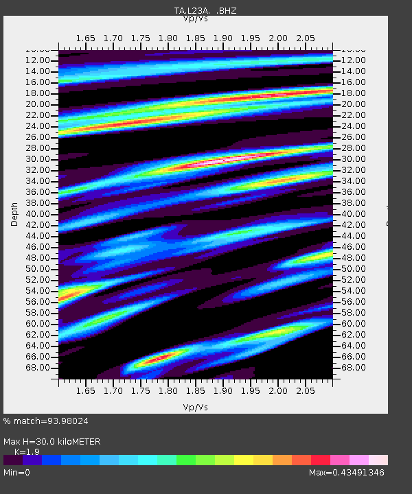
L23A Garrett, WY, USA - Earthquake Result Viewer
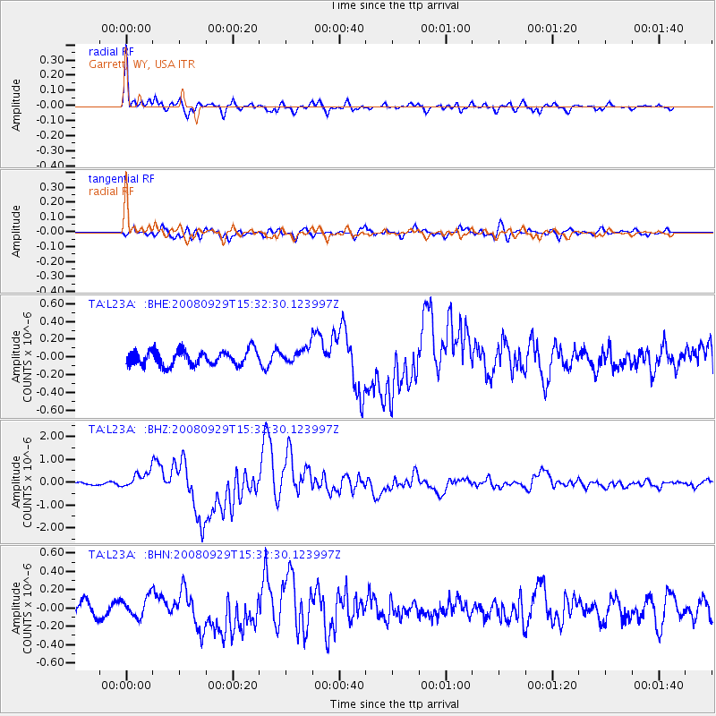
Earthquake location: Kermadec Islands, New Zealand
Earthquake latitude/longitude: -29.8/-177.7
Earthquake time(UTC): 2008/09/29 (273) 15:19:31 GMT
Earthquake Depth: 36 km
Earthquake Magnitude: 6.5 MB, 6.7 MS, 7.0 MW, 7.0 MW
Earthquake Catalog/Contributor: WHDF/NEIC
Network: TA USArray Transportable Network (new EarthScope stations)
Station: L23A Garrett, WY, USA
Lat/Lon: 42.11 N/105.70 W
Elevation: 2153 m
Distance: 97.5 deg
Az: 45.528 deg
Baz: 236.51 deg
Ray Param: 0.04018979
Estimated Moho Depth: 30.0 km
Estimated Crust Vp/Vs: 1.90
Assumed Crust Vp: 6.159 km/s
Estimated Crust Vs: 3.241 km/s
Estimated Crust Poisson's Ratio: 0.31
Radial Match: 93.98024 %
Radial Bump: 400
Transverse Match: 63.818813 %
Transverse Bump: 400
SOD ConfigId: 2560
Insert Time: 2010-03-06 11:21:47.452 +0000
GWidth: 2.5
Max Bumps: 400
Tol: 0.001

Signal To Noise

ChannelStoNSTALTA
TA:L23A: :BHZ:20080929T15:32:30.123997Z5.3196323.7078752E-76.970172E-8
TA:L23A: :BHN:20080929T15:32:30.123997Z0.95406281.1369416E-71.19168426E-7
TA:L23A: :BHE:20080929T15:32:30.123997Z1.04721848.723169E-88.329846E-8
Arrivals
Ps4.5 SECOND
PpPs14 SECOND
PsPs/PpSs18 SECOND