You are here: Home > Network List > TA - USArray Transportable Network (new EarthScope stations) Stations List
> Station L23A Garrett, WY, USA > Earthquake Result Viewer
L23A Garrett, WY, USA - Earthquake Result Viewer
| Earthquake location: |
Costa Rica |
| Earthquake latitude/longitude: |
10.2/-84.2 |
| Earthquake time(UTC): |
2009/01/08 (008) 19:21:35 GMT |
| Earthquake Depth: |
14 km |
| Earthquake Magnitude: |
5.7 MB, 6.0 MS, 6.1 MW, 6.1 MW |
| Earthquake Catalog/Contributor: |
WHDF/NEIC |
|
| Network: |
TA USArray Transportable Network (new EarthScope stations) |
| Station: |
L23A Garrett, WY, USA |
| Lat/Lon: |
42.11 N/105.70 W |
| Elevation: |
2153 m |
|
| Distance: |
37.0 deg |
| Az: |
333.048 deg |
| Baz: |
143.15 deg |
| Ray Param: |
0.076366894 |
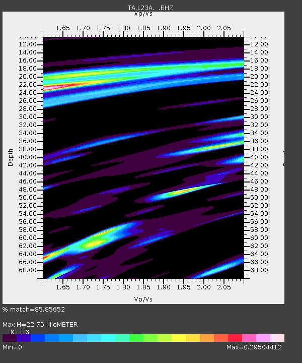
| Estimated Moho Depth: |
22.75 km |
| Estimated Crust Vp/Vs: |
1.60 |
| Assumed Crust Vp: |
6.159 km/s |
| Estimated Crust Vs: |
3.849 km/s |
| Estimated Crust Poisson's Ratio: |
0.18 |
|
| Radial Match: |
85.85652 % |
| Radial Bump: |
400 |
| Transverse Match: |
38.52072 % |
| Transverse Bump: |
400 |
| SOD ConfigId: |
2834 |
| Insert Time: |
2010-03-06 11:21:48.643 +0000 |
| GWidth: |
2.5 |
| Max Bumps: |
400 |
| Tol: |
0.001 |
|

Signal To Noise
| Channel | StoN | STA | LTA |
| TA:L23A: :BHZ:20090108T19:28:13.750015Z | 6.3400106 | 8.298822E-7 | 1.3089603E-7 |
| TA:L23A: :BHN:20090108T19:28:13.750015Z | 3.7546098 | 5.387457E-7 | 1.4348913E-7 |
| TA:L23A: :BHE:20090108T19:28:13.750015Z | 2.012705 | 2.5943717E-7 | 1.2889974E-7 |
| Arrivals |
| Ps | 2.4 SECOND |
| PpPs | 8.9 SECOND |
| PsPs/PpSs | 11 SECOND |


