You are here: Home > Network List > TA - USArray Transportable Network (new EarthScope stations) Stations List
> Station L23A Garrett, WY, USA > Earthquake Result Viewer
L23A Garrett, WY, USA - Earthquake Result Viewer
| Earthquake location: |
Samoa Islands Region |
| Earthquake latitude/longitude: |
-15.2/-172.6 |
| Earthquake time(UTC): |
2009/08/30 (242) 14:51:32 GMT |
| Earthquake Depth: |
11 km |
| Earthquake Magnitude: |
6.4 MB, 6.3 MS, 6.6 MW, 6.6 MW |
| Earthquake Catalog/Contributor: |
WHDF/NEIC |
|
| Network: |
TA USArray Transportable Network (new EarthScope stations) |
| Station: |
L23A Garrett, WY, USA |
| Lat/Lon: |
42.11 N/105.70 W |
| Elevation: |
2153 m |
|
| Distance: |
83.8 deg |
| Az: |
43.491 deg |
| Baz: |
243.248 deg |
| Ray Param: |
0.045920767 |
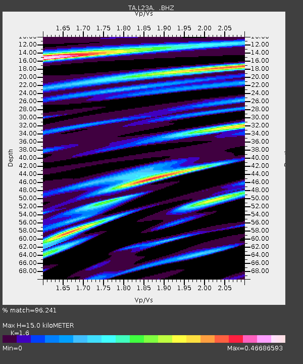
| Estimated Moho Depth: |
15.0 km |
| Estimated Crust Vp/Vs: |
1.60 |
| Assumed Crust Vp: |
6.159 km/s |
| Estimated Crust Vs: |
3.849 km/s |
| Estimated Crust Poisson's Ratio: |
0.18 |
|
| Radial Match: |
96.241 % |
| Radial Bump: |
282 |
| Transverse Match: |
91.63886 % |
| Transverse Bump: |
400 |
| SOD ConfigId: |
2622 |
| Insert Time: |
2010-03-06 11:22:01.362 +0000 |
| GWidth: |
2.5 |
| Max Bumps: |
400 |
| Tol: |
0.001 |
|

Signal To Noise
| Channel | StoN | STA | LTA |
| TA:L23A: :BHZ:20090830T15:03:30.725022Z | 41.08114 | 4.1960657E-6 | 1.0214093E-7 |
| TA:L23A: :BHN:20090830T15:03:30.725022Z | 5.6566906 | 4.4241554E-7 | 7.8211016E-8 |
| TA:L23A: :BHE:20090830T15:03:30.725022Z | 16.35553 | 1.1462531E-6 | 7.008352E-8 |
| Arrivals |
| Ps | 1.5 SECOND |
| PpPs | 6.2 SECOND |
| PsPs/PpSs | 7.7 SECOND |


