You are here: Home > Network List > TA - USArray Transportable Network (new EarthScope stations) Stations List
> Station L23A Garrett, WY, USA > Earthquake Result Viewer
L23A Garrett, WY, USA - Earthquake Result Viewer
| Earthquake location: |
Samoa Islands Region |
| Earthquake latitude/longitude: |
-15.4/-172.3 |
| Earthquake time(UTC): |
2009/10/19 (292) 22:49:38 GMT |
| Earthquake Depth: |
18 km |
| Earthquake Magnitude: |
6.2 MB, 5.7 MS, 6.0 MW, 5.9 MW |
| Earthquake Catalog/Contributor: |
WHDF/NEIC |
|
| Network: |
TA USArray Transportable Network (new EarthScope stations) |
| Station: |
L23A Garrett, WY, USA |
| Lat/Lon: |
42.11 N/105.70 W |
| Elevation: |
2153 m |
|
| Distance: |
83.7 deg |
| Az: |
43.377 deg |
| Baz: |
242.937 deg |
| Ray Param: |
0.045982983 |
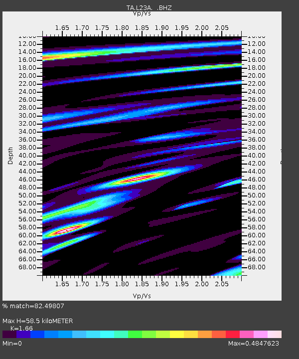
| Estimated Moho Depth: |
58.5 km |
| Estimated Crust Vp/Vs: |
1.66 |
| Assumed Crust Vp: |
6.159 km/s |
| Estimated Crust Vs: |
3.71 km/s |
| Estimated Crust Poisson's Ratio: |
0.22 |
|
| Radial Match: |
82.49807 % |
| Radial Bump: |
365 |
| Transverse Match: |
67.40217 % |
| Transverse Bump: |
388 |
| SOD ConfigId: |
2622 |
| Insert Time: |
2010-03-06 11:22:14.467 +0000 |
| GWidth: |
2.5 |
| Max Bumps: |
400 |
| Tol: |
0.001 |
|

Signal To Noise
| Channel | StoN | STA | LTA |
| TA:L23A: :BHZ:20091019T23:01:34.625027Z | 12.315991 | 1.755595E-6 | 1.4254597E-7 |
| TA:L23A: :BHN:20091019T23:01:34.625027Z | 1.619822 | 2.703671E-7 | 1.669116E-7 |
| TA:L23A: :BHE:20091019T23:01:34.625027Z | 4.531251 | 4.7849835E-7 | 1.0559961E-7 |
| Arrivals |
| Ps | 6.4 SECOND |
| PpPs | 25 SECOND |
| PsPs/PpSs | 31 SECOND |


