You are here: Home > Network List > TA - USArray Transportable Network (new EarthScope stations) Stations List
> Station L23A Garrett, WY, USA > Earthquake Result Viewer
L23A Garrett, WY, USA - Earthquake Result Viewer
| Earthquake location: |
Ryukyu Islands, Japan |
| Earthquake latitude/longitude: |
29.2/129.8 |
| Earthquake time(UTC): |
2009/10/30 (303) 07:03:39 GMT |
| Earthquake Depth: |
34 km |
| Earthquake Magnitude: |
6.3 MB, 6.8 MS, 6.8 MW, 6.8 MW |
| Earthquake Catalog/Contributor: |
WHDF/NEIC |
|
| Network: |
TA USArray Transportable Network (new EarthScope stations) |
| Station: |
L23A Garrett, WY, USA |
| Lat/Lon: |
42.11 N/105.70 W |
| Elevation: |
2153 m |
|
| Distance: |
92.5 deg |
| Az: |
37.855 deg |
| Baz: |
313.865 deg |
| Ray Param: |
0.041429482 |
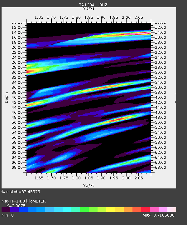
| Estimated Moho Depth: |
14.0 km |
| Estimated Crust Vp/Vs: |
2.09 |
| Assumed Crust Vp: |
6.159 km/s |
| Estimated Crust Vs: |
2.95 km/s |
| Estimated Crust Poisson's Ratio: |
0.35 |
|
| Radial Match: |
87.45979 % |
| Radial Bump: |
400 |
| Transverse Match: |
59.587887 % |
| Transverse Bump: |
400 |
| SOD ConfigId: |
2622 |
| Insert Time: |
2010-03-06 11:22:16.096 +0000 |
| GWidth: |
2.5 |
| Max Bumps: |
400 |
| Tol: |
0.001 |
|

Signal To Noise
| Channel | StoN | STA | LTA |
| TA:L23A: :BHZ:20091030T07:16:15.525029Z | 6.6778445 | 1.056623E-6 | 1.5822815E-7 |
| TA:L23A: :BHN:20091030T07:16:15.525029Z | 2.3103802 | 3.4857123E-7 | 1.508718E-7 |
| TA:L23A: :BHE:20091030T07:16:15.525029Z | 2.427607 | 2.741657E-7 | 1.12936604E-7 |
| Arrivals |
| Ps | 2.5 SECOND |
| PpPs | 6.9 SECOND |
| PsPs/PpSs | 9.4 SECOND |


