You are here: Home > Network List > TA - USArray Transportable Network (new EarthScope stations) Stations List
> Station L23A Garrett, WY, USA > Earthquake Result Viewer
L23A Garrett, WY, USA - Earthquake Result Viewer
| Earthquake location: |
Kermadec Islands Region |
| Earthquake latitude/longitude: |
-27.4/-176.3 |
| Earthquake time(UTC): |
2009/02/18 (049) 21:53:45 GMT |
| Earthquake Depth: |
25 km |
| Earthquake Magnitude: |
6.8 MB, 7.2 MS, 6.9 MW, 6.9 MW |
| Earthquake Catalog/Contributor: |
WHDF/NEIC |
|
| Network: |
TA USArray Transportable Network (new EarthScope stations) |
| Station: |
L23A Garrett, WY, USA |
| Lat/Lon: |
42.11 N/105.70 W |
| Elevation: |
2153 m |
|
| Distance: |
95.0 deg |
| Az: |
44.796 deg |
| Baz: |
237.324 deg |
| Ray Param: |
0.040896006 |
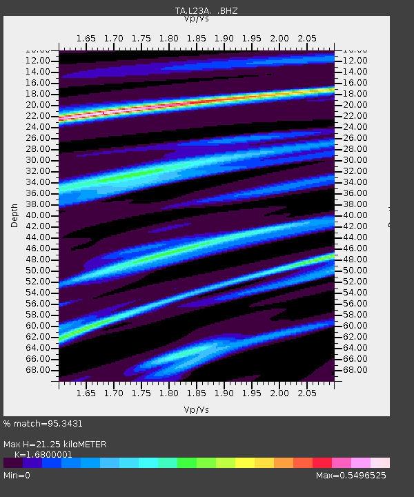
| Estimated Moho Depth: |
21.25 km |
| Estimated Crust Vp/Vs: |
1.68 |
| Assumed Crust Vp: |
6.159 km/s |
| Estimated Crust Vs: |
3.666 km/s |
| Estimated Crust Poisson's Ratio: |
0.23 |
|
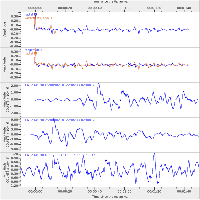
| Radial Match: |
95.3431 % |
| Radial Bump: |
253 |
| Transverse Match: |
77.99133 % |
| Transverse Bump: |
400 |
| SOD ConfigId: |
2658 |
| Insert Time: |
2010-03-06 11:22:19.562 +0000 |
| GWidth: |
2.5 |
| Max Bumps: |
400 |
| Tol: |
0.001 |
|
Signal To Noise
| Channel | StoN | STA | LTA |
| TA:L23A: :BHZ:20090218T22:06:33.824001Z | 4.558461 | 1.1069865E-6 | 2.4284213E-7 |
| TA:L23A: :BHN:20090218T22:06:33.824001Z | 1.9286938 | 3.3266284E-7 | 1.724809E-7 |
| TA:L23A: :BHE:20090218T22:06:33.824001Z | 3.4588575 | 4.2758745E-7 | 1.23621E-7 |
| Arrivals |
| Ps | 2.4 SECOND |
| PpPs | 9.1 SECOND |
| PsPs/PpSs | 11 SECOND |


