You are here: Home > Network List > TA - USArray Transportable Network (new EarthScope stations) Stations List
> Station G31M Satah River, YT, CAN > Earthquake Result Viewer
G31M Satah River, YT, CAN - Earthquake Result Viewer
*The percent match for this event was below the threshold and hence no stack was calculated.
| Earthquake location: |
South Of Mariana Islands |
| Earthquake latitude/longitude: |
12.8/145.8 |
| Earthquake time(UTC): |
2018/05/22 (142) 00:26:04 GMT |
| Earthquake Depth: |
10 km |
| Earthquake Magnitude: |
6.0 Mi |
| Earthquake Catalog/Contributor: |
NEIC PDE/pt |
|
| Network: |
TA USArray Transportable Network (new EarthScope stations) |
| Station: |
G31M Satah River, YT, CAN |
| Lat/Lon: |
66.92 N/134.27 W |
| Elevation: |
61 m |
|
| Distance: |
74.4 deg |
| Az: |
23.766 deg |
| Baz: |
265.858 deg |
| Ray Param: |
$rayparam |
*The percent match for this event was below the threshold and hence was not used in the summary stack. |
|
| Radial Match: |
69.2018 % |
| Radial Bump: |
400 |
| Transverse Match: |
50.49416 % |
| Transverse Bump: |
400 |
| SOD ConfigId: |
13570011 |
| Insert Time: |
2019-04-30 07:17:23.090 +0000 |
| GWidth: |
2.5 |
| Max Bumps: |
400 |
| Tol: |
0.001 |
|
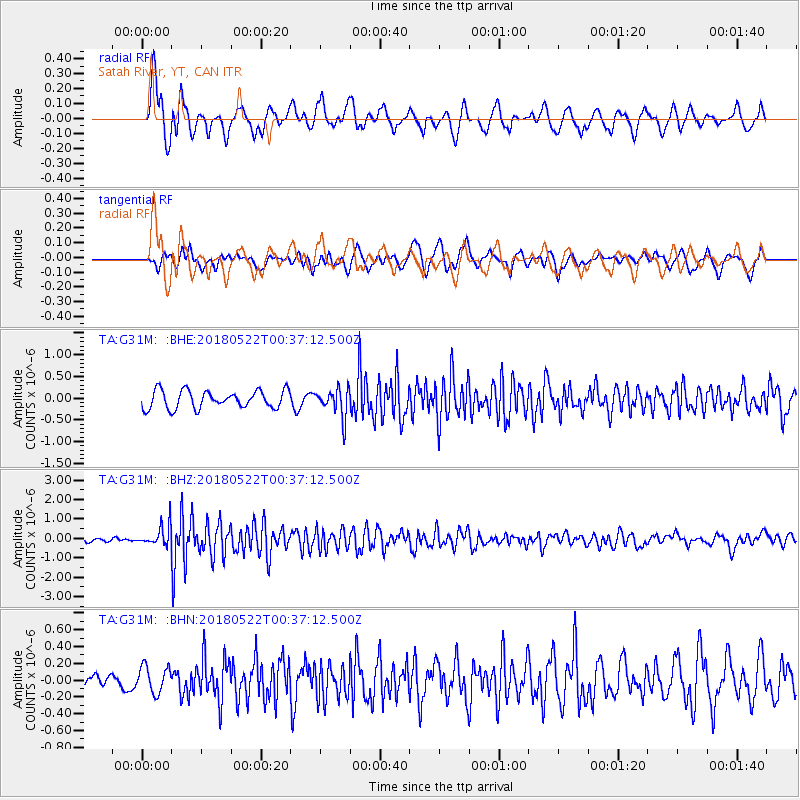
Signal To Noise
| Channel | StoN | STA | LTA |
| TA:G31M: :BHZ:20180522T00:37:12.500Z | 4.2665133 | 5.3125484E-7 | 1.2451733E-7 |
| TA:G31M: :BHN:20180522T00:37:12.500Z | 0.9721318 | 1.5612935E-7 | 1.6060513E-7 |
| TA:G31M: :BHE:20180522T00:37:12.500Z | 0.7937128 | 1.5920821E-7 | 2.0058667E-7 |
| Arrivals |
| Ps | |
| PpPs | |
| PsPs/PpSs | |


