You are here: Home > Network List > TA - USArray Transportable Network (new EarthScope stations) Stations List
> Station H16K Elim, AK, USA > Earthquake Result Viewer
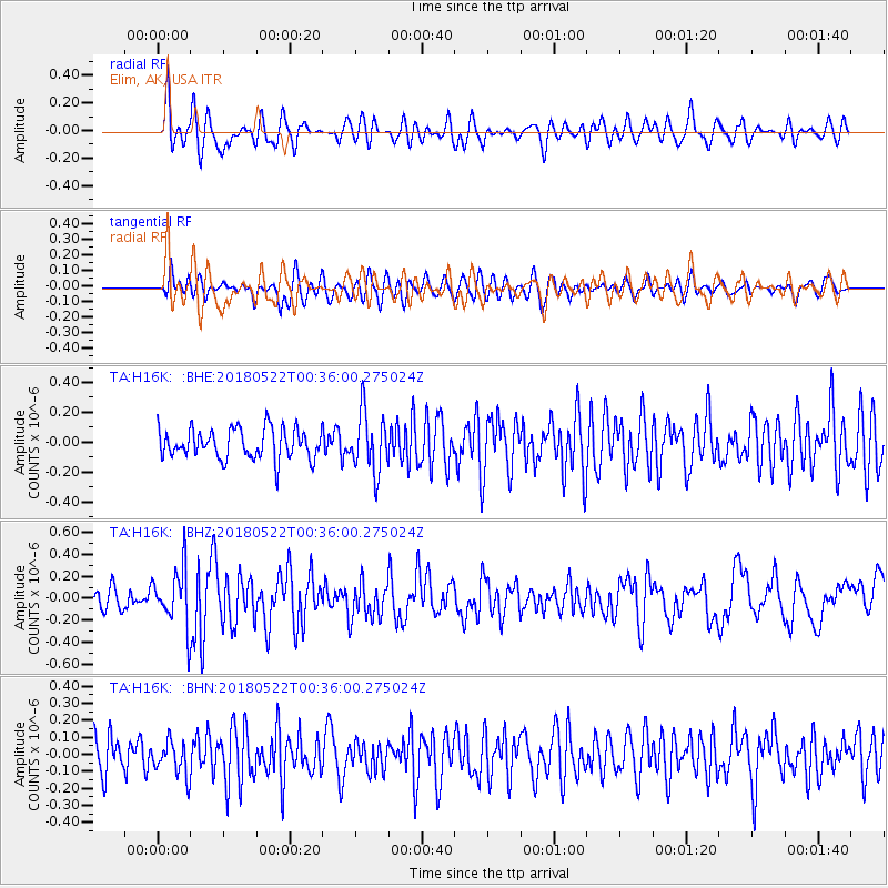
H16K Elim, AK, USA - Earthquake Result Viewer
*The percent match for this event was below the threshold and hence no stack was calculated.
| Earthquake location: |
South Of Mariana Islands |
| Earthquake latitude/longitude: |
12.8/145.8 |
| Earthquake time(UTC): |
2018/05/22 (142) 00:26:04 GMT |
| Earthquake Depth: |
10 km |
| Earthquake Magnitude: |
6.0 Mi |
| Earthquake Catalog/Contributor: |
NEIC PDE/pt |
|
| Network: |
TA USArray Transportable Network (new EarthScope stations) |
| Station: |
H16K Elim, AK, USA |
| Lat/Lon: |
64.64 N/162.24 W |
| Elevation: |
216 m |
|
| Distance: |
62.8 deg |
| Az: |
22.429 deg |
| Baz: |
239.801 deg |
| Ray Param: |
$rayparam |
*The percent match for this event was below the threshold and hence was not used in the summary stack. |
|
| Radial Match: |
64.92518 % |
| Radial Bump: |
400 |
| Transverse Match: |
48.79968 % |
| Transverse Bump: |
400 |
| SOD ConfigId: |
13570011 |
| Insert Time: |
2019-04-30 07:17:24.295 +0000 |
| GWidth: |
2.5 |
| Max Bumps: |
400 |
| Tol: |
0.001 |
|
Signal To Noise
| Channel | StoN | STA | LTA |
| TA:H16K: :BHZ:20180522T00:36:00.275024Z | 2.2100918 | 2.5838028E-7 | 1.169093E-7 |
| TA:H16K: :BHN:20180522T00:36:00.275024Z | 0.7826428 | 9.937755E-8 | 1.269769E-7 |
| TA:H16K: :BHE:20180522T00:36:00.275024Z | 1.8374612 | 1.819087E-7 | 9.9000026E-8 |
| Arrivals |
| Ps | |
| PpPs | |
| PsPs/PpSs | |


