You are here: Home > Network List > TA - USArray Transportable Network (new EarthScope stations) Stations List
> Station L23A Garrett, WY, USA > Earthquake Result Viewer
L23A Garrett, WY, USA - Earthquake Result Viewer

| Earthquake location: |
Honduras |
| Earthquake latitude/longitude: |
15.8/-86.9 |
| Earthquake time(UTC): |
2009/06/08 (159) 05:13:14 GMT |
| Earthquake Depth: |
10 km |
| Earthquake Magnitude: |
5.5 MB, 4.9 MS, 5.4 MW, 5.4 MW |
| Earthquake Catalog/Contributor: |
WHDF/NEIC |
|
| Network: |
TA USArray Transportable Network (new EarthScope stations) |
| Station: |
L23A Garrett, WY, USA |
| Lat/Lon: |
42.11 N/105.70 W |
| Elevation: |
2153 m |
|
| Distance: |
30.8 deg |
| Az: |
332.051 deg |
| Baz: |
142.668 deg |
| Ray Param: |
0.079227984 |
| Estimated Moho Depth: |
69.75 km |
| Estimated Crust Vp/Vs: |
1.75 |
| Assumed Crust Vp: |
6.159 km/s |
| Estimated Crust Vs: |
3.529 km/s |
| Estimated Crust Poisson's Ratio: |
0.26 |
|
| Radial Match: |
84.88529 % |
| Radial Bump: |
392 |
| Transverse Match: |
63.3117 % |
| Transverse Bump: |
400 |
| SOD ConfigId: |
2648 |
| Insert Time: |
2010-03-06 11:22:31.853 +0000 |
| GWidth: |
2.5 |
| Max Bumps: |
400 |
| Tol: |
0.001 |
|
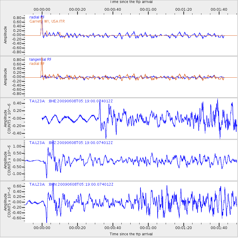
Signal To Noise
| Channel | StoN | STA | LTA |
| TA:L23A: :BHZ:20090608T05:19:00.074012Z | 9.232887 | 4.810107E-7 | 5.2097544E-8 |
| TA:L23A: :BHN:20090608T05:19:00.074012Z | 5.905242 | 2.490478E-7 | 4.2174022E-8 |
| TA:L23A: :BHE:20090608T05:19:00.074012Z | 3.0432124 | 1.7677993E-7 | 5.8089913E-8 |
| Arrivals |
| Ps | 9.1 SECOND |
| PpPs | 29 SECOND |
| PsPs/PpSs | 38 SECOND |


