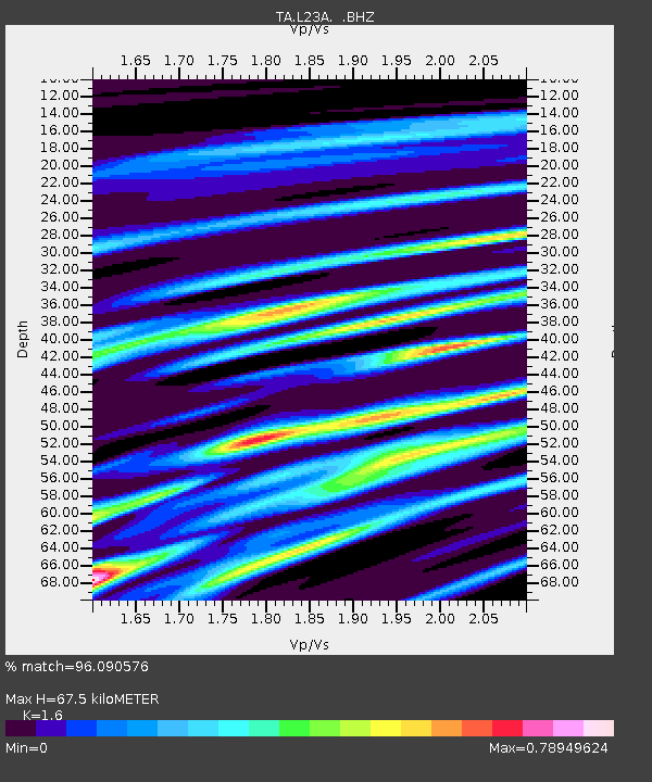
L23A Garrett, WY, USA - Earthquake Result Viewer

Earthquake location: Rat Islands, Aleutian Islands
Earthquake latitude/longitude: 50.4/177.0
Earthquake time(UTC): 2009/07/06 (187) 14:53:12 GMT
Earthquake Depth: 22 km
Earthquake Magnitude: 6.0 MB, 5.8 MS, 6.1 MW, 6.0 MW
Earthquake Catalog/Contributor: WHDF/NEIC
Network: TA USArray Transportable Network (new EarthScope stations)
Station: L23A Garrett, WY, USA
Lat/Lon: 42.11 N/105.70 W
Elevation: 2153 m
Distance: 51.8 deg
Az: 67.438 deg
Baz: 307.467 deg
Ray Param: 0.06713484
Estimated Moho Depth: 67.5 km
Estimated Crust Vp/Vs: 1.60
Assumed Crust Vp: 6.159 km/s
Estimated Crust Vs: 3.849 km/s
Estimated Crust Poisson's Ratio: 0.18
Radial Match: 96.090576 %
Radial Bump: 400
Transverse Match: 85.59831 %
Transverse Bump: 400
SOD ConfigId: 2648
Insert Time: 2010-03-06 11:22:43.749 +0000
GWidth: 2.5
Max Bumps: 400
Tol: 0.001

Signal To Noise

ChannelStoNSTALTA
TA:L23A: :BHZ:20090706T15:01:47.549021Z7.1829221.9247016E-62.6795522E-7
TA:L23A: :BHN:20090706T15:01:47.549021Z7.1430149.275503E-71.2985419E-7
TA:L23A: :BHE:20090706T15:01:47.549021Z5.31092747.735985E-71.4566166E-7
Arrivals
Ps7.0 SECOND
PpPs27 SECOND
PsPs/PpSs34 SECOND