You are here: Home > Network List > TA - USArray Transportable Network (new EarthScope stations) Stations List
> Station L23A Garrett, WY, USA > Earthquake Result Viewer
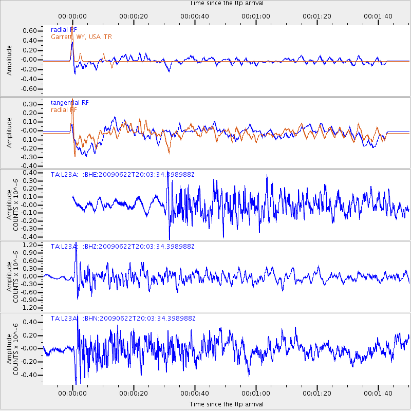
L23A Garrett, WY, USA - Earthquake Result Viewer
*The percent match for this event was below the threshold and hence no stack was calculated.
| Earthquake location: |
Andreanof Islands, Aleutian Is. |
| Earthquake latitude/longitude: |
51.3/-178.2 |
| Earthquake time(UTC): |
2009/06/22 (173) 19:55:24 GMT |
| Earthquake Depth: |
35 km |
| Earthquake Magnitude: |
5.6 MB, 5.6 MW, 5.6 MW |
| Earthquake Catalog/Contributor: |
WHDF/NEIC |
|
| Network: |
TA USArray Transportable Network (new EarthScope stations) |
| Station: |
L23A Garrett, WY, USA |
| Lat/Lon: |
42.11 N/105.70 W |
| Elevation: |
2153 m |
|
| Distance: |
48.7 deg |
| Az: |
70.912 deg |
| Baz: |
307.082 deg |
| Ray Param: |
$rayparam |
*The percent match for this event was below the threshold and hence was not used in the summary stack. |
|
| Radial Match: |
62.319935 % |
| Radial Bump: |
400 |
| Transverse Match: |
45.986687 % |
| Transverse Bump: |
400 |
| SOD ConfigId: |
2648 |
| Insert Time: |
2010-03-06 11:24:19.793 +0000 |
| GWidth: |
2.5 |
| Max Bumps: |
400 |
| Tol: |
0.001 |
|
Signal To Noise
| Channel | StoN | STA | LTA |
| TA:L23A: :BHZ:20090622T20:03:34.398988Z | 5.6782475 | 4.4252E-7 | 7.79325E-8 |
| TA:L23A: :BHN:20090622T20:03:34.398988Z | 2.5970268 | 2.35036E-7 | 9.050195E-8 |
| TA:L23A: :BHE:20090622T20:03:34.398988Z | 3.4419405 | 1.7339659E-7 | 5.0377565E-8 |
| Arrivals |
| Ps | |
| PpPs | |
| PsPs/PpSs | |


