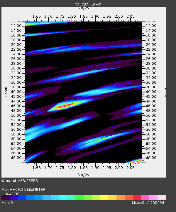
J22A Midwest, WY, USA - Earthquake Result Viewer

Earthquake location: Andreanof Islands, Aleutian Is.
Earthquake latitude/longitude: 51.6/-174.4
Earthquake time(UTC): 2008/11/02 (307) 13:48:42 GMT
Earthquake Depth: 36 km
Earthquake Magnitude: 5.7 MB, 5.8 MS, 6.1 MW, 6.1 MW
Earthquake Catalog/Contributor: WHDF/NEIC
Network: TA USArray Transportable Network (new EarthScope stations)
Station: J22A Midwest, WY, USA
Lat/Lon: 43.41 N/106.48 W
Elevation: 1587 m
Distance: 45.1 deg
Az: 72.467 deg
Baz: 305.216 deg
Ray Param: 0.07144003
Estimated Moho Depth: 69.25 km
Estimated Crust Vp/Vs: 2.09
Assumed Crust Vp: 6.178 km/s
Estimated Crust Vs: 2.956 km/s
Estimated Crust Poisson's Ratio: 0.35
Radial Match: 85.23855 %
Radial Bump: 400
Transverse Match: 60.72833 %
Transverse Bump: 400
SOD ConfigId: 2658
Insert Time: 2010-03-06 11:24:58.961 +0000
GWidth: 2.5
Max Bumps: 400
Tol: 0.001

Signal To Noise

ChannelStoNSTALTA
TA:J22A: :BHZ:20081102T13:56:24.825005Z4.7087121.0217809E-62.1699795E-7
TA:J22A: :BHN:20081102T13:56:24.825005Z2.15217956.322017E-72.937495E-7
TA:J22A: :BHE:20081102T13:56:24.825005Z1.57120433.2451553E-72.0653935E-7
Arrivals
Ps13 SECOND
PpPs33 SECOND
PsPs/PpSs46 SECOND