You are here: Home > Network List > TA - USArray Transportable Network (new EarthScope stations) Stations List
> Station 121A Cookes Peak, Deming, NM, USA > Earthquake Result Viewer
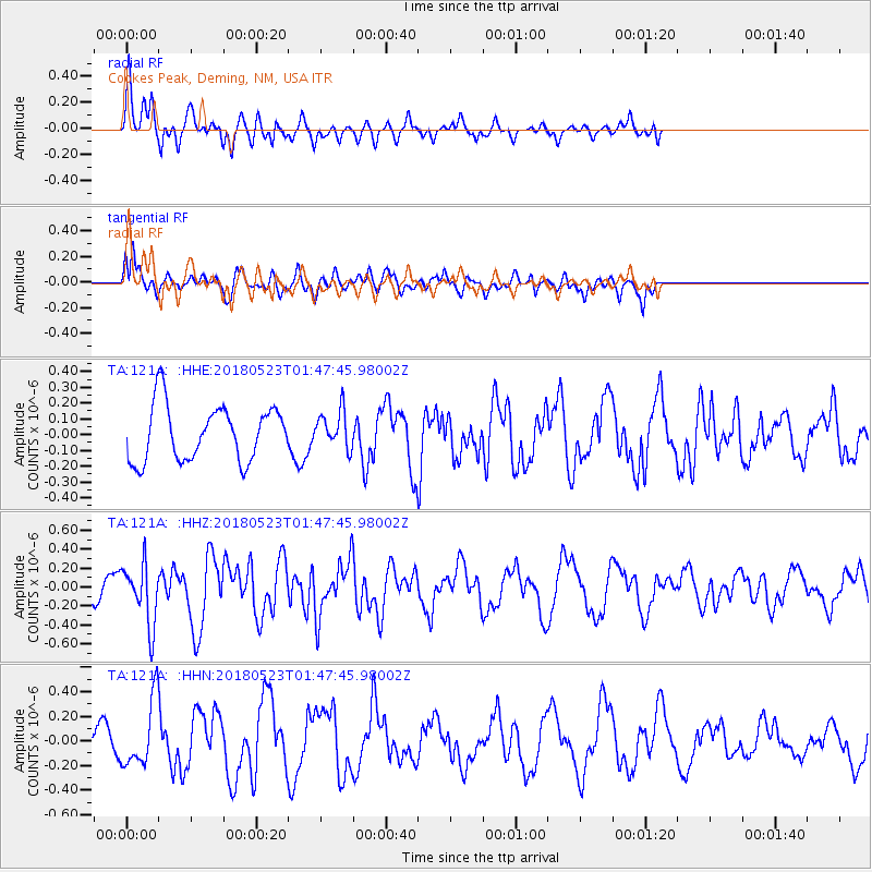
121A Cookes Peak, Deming, NM, USA - Earthquake Result Viewer
*The percent match for this event was below the threshold and hence no stack was calculated.
| Earthquake location: |
Near East Coast Of Kamchatka |
| Earthquake latitude/longitude: |
55.3/161.9 |
| Earthquake time(UTC): |
2018/05/23 (143) 01:37:48 GMT |
| Earthquake Depth: |
59 km |
| Earthquake Magnitude: |
5.4 Mww |
| Earthquake Catalog/Contributor: |
NEIC PDE/us |
|
| Network: |
TA USArray Transportable Network (new EarthScope stations) |
| Station: |
121A Cookes Peak, Deming, NM, USA |
| Lat/Lon: |
32.53 N/107.79 W |
| Elevation: |
1652 m |
|
| Distance: |
64.1 deg |
| Az: |
69.855 deg |
| Baz: |
320.503 deg |
| Ray Param: |
$rayparam |
*The percent match for this event was below the threshold and hence was not used in the summary stack. |
|
| Radial Match: |
82.529785 % |
| Radial Bump: |
344 |
| Transverse Match: |
61.569996 % |
| Transverse Bump: |
400 |
| SOD ConfigId: |
13570011 |
| Insert Time: |
2019-04-30 07:29:44.629 +0000 |
| GWidth: |
2.5 |
| Max Bumps: |
400 |
| Tol: |
0.001 |
|
Signal To Noise
| Channel | StoN | STA | LTA |
| TA:121A: :HHZ:20180523T01:47:45.98002Z | 3.1679616 | 3.188119E-7 | 1.0063629E-7 |
| TA:121A: :HHN:20180523T01:47:45.98002Z | 2.0435777 | 2.7398656E-7 | 1.3407201E-7 |
| TA:121A: :HHE:20180523T01:47:45.98002Z | 0.67562383 | 1.1844873E-7 | 1.7531757E-7 |
| Arrivals |
| Ps | |
| PpPs | |
| PsPs/PpSs | |


