You are here: Home > Network List > TA - USArray Transportable Network (new EarthScope stations) Stations List
> Station I30M Mount Dempster, Yukon, CAN > Earthquake Result Viewer
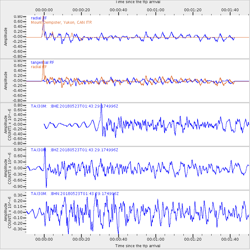
I30M Mount Dempster, Yukon, CAN - Earthquake Result Viewer
*The percent match for this event was below the threshold and hence no stack was calculated.
| Earthquake location: |
Near East Coast Of Kamchatka |
| Earthquake latitude/longitude: |
55.3/161.9 |
| Earthquake time(UTC): |
2018/05/23 (143) 01:37:48 GMT |
| Earthquake Depth: |
59 km |
| Earthquake Magnitude: |
5.4 Mww |
| Earthquake Catalog/Contributor: |
NEIC PDE/us |
|
| Network: |
TA USArray Transportable Network (new EarthScope stations) |
| Station: |
I30M Mount Dempster, Yukon, CAN |
| Lat/Lon: |
65.22 N/136.38 W |
| Elevation: |
1399 m |
|
| Distance: |
30.9 deg |
| Az: |
46.254 deg |
| Baz: |
281.178 deg |
| Ray Param: |
$rayparam |
*The percent match for this event was below the threshold and hence was not used in the summary stack. |
|
| Radial Match: |
69.02344 % |
| Radial Bump: |
400 |
| Transverse Match: |
52.03005 % |
| Transverse Bump: |
400 |
| SOD ConfigId: |
13570011 |
| Insert Time: |
2019-04-30 07:29:52.591 +0000 |
| GWidth: |
2.5 |
| Max Bumps: |
400 |
| Tol: |
0.001 |
|
Signal To Noise
| Channel | StoN | STA | LTA |
| TA:I30M: :BHZ:20180523T01:43:29.174996Z | 5.223665 | 3.8401654E-7 | 7.351477E-8 |
| TA:I30M: :BHN:20180523T01:43:29.174996Z | 1.8196498 | 9.862434E-8 | 5.4199628E-8 |
| TA:I30M: :BHE:20180523T01:43:29.174996Z | 5.238546 | 3.4310847E-7 | 6.549689E-8 |
| Arrivals |
| Ps | |
| PpPs | |
| PsPs/PpSs | |


