You are here: Home > Network List > IU - Global Seismograph Network (GSN - IRIS/USGS) Stations List
> Station MAKZ Makanchi, Kazakhstan > Earthquake Result Viewer
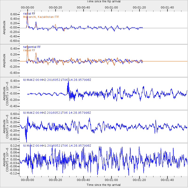
MAKZ Makanchi, Kazakhstan - Earthquake Result Viewer
*The percent match for this event was below the threshold and hence no stack was calculated.
| Earthquake location: |
Southeast Of Honshu, Japan |
| Earthquake latitude/longitude: |
30.9/140.1 |
| Earthquake time(UTC): |
2016/05/21 (142) 06:06:42 GMT |
| Earthquake Depth: |
130 km |
| Earthquake Magnitude: |
5.5 MB |
| Earthquake Catalog/Contributor: |
NEIC PDE/NEIC COMCAT |
|
| Network: |
IU Global Seismograph Network (GSN - IRIS/USGS) |
| Station: |
MAKZ Makanchi, Kazakhstan |
| Lat/Lon: |
46.81 N/81.98 E |
| Elevation: |
600 m |
|
| Distance: |
46.9 deg |
| Az: |
306.962 deg |
| Baz: |
88.335 deg |
| Ray Param: |
$rayparam |
*The percent match for this event was below the threshold and hence was not used in the summary stack. |
|
| Radial Match: |
70.63063 % |
| Radial Bump: |
375 |
| Transverse Match: |
53.138012 % |
| Transverse Bump: |
400 |
| SOD ConfigId: |
1475611 |
| Insert Time: |
2016-06-04 06:11:23.306 +0000 |
| GWidth: |
2.5 |
| Max Bumps: |
400 |
| Tol: |
0.001 |
|
Signal To Noise
| Channel | StoN | STA | LTA |
| IU:MAKZ:00:HHZ:20160521T06:14:28.957998Z | 5.581429 | 2.2417521E-7 | 4.0164487E-8 |
| IU:MAKZ:00:HH1:20160521T06:14:28.957998Z | 1.1466666 | 4.4534904E-8 | 3.883858E-8 |
| IU:MAKZ:00:HH2:20160521T06:14:28.957998Z | 6.5864177 | 1.3900292E-7 | 2.1104482E-8 |
| Arrivals |
| Ps | |
| PpPs | |
| PsPs/PpSs | |


