You are here: Home > Network List > US - United States National Seismic Network Stations List
> Station AGMN Agassiz National Wildlife Refuge, Minnesota, USA > Earthquake Result Viewer
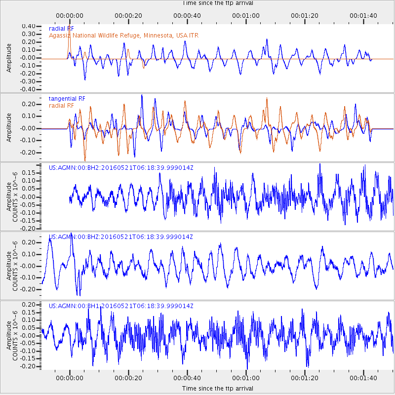
AGMN Agassiz National Wildlife Refuge, Minnesota, USA - Earthquake Result Viewer
*The percent match for this event was below the threshold and hence no stack was calculated.
| Earthquake location: |
Southeast Of Honshu, Japan |
| Earthquake latitude/longitude: |
30.9/140.1 |
| Earthquake time(UTC): |
2016/05/21 (142) 06:06:42 GMT |
| Earthquake Depth: |
130 km |
| Earthquake Magnitude: |
5.5 MB |
| Earthquake Catalog/Contributor: |
NEIC PDE/NEIC COMCAT |
|
| Network: |
US United States National Seismic Network |
| Station: |
AGMN Agassiz National Wildlife Refuge, Minnesota, USA |
| Lat/Lon: |
48.30 N/95.86 W |
| Elevation: |
351 m |
|
| Distance: |
86.6 deg |
| Az: |
33.646 deg |
| Baz: |
314.521 deg |
| Ray Param: |
$rayparam |
*The percent match for this event was below the threshold and hence was not used in the summary stack. |
|
| Radial Match: |
56.498833 % |
| Radial Bump: |
400 |
| Transverse Match: |
65.900764 % |
| Transverse Bump: |
400 |
| SOD ConfigId: |
1475611 |
| Insert Time: |
2016-06-04 06:15:59.650 +0000 |
| GWidth: |
2.5 |
| Max Bumps: |
400 |
| Tol: |
0.001 |
|
Signal To Noise
| Channel | StoN | STA | LTA |
| US:AGMN:00:BHZ:20160521T06:18:39.999014Z | 1.5941103 | 1.4093018E-7 | 8.84068E-8 |
| US:AGMN:00:BH1:20160521T06:18:39.999014Z | 0.84706104 | 6.034497E-8 | 7.12404E-8 |
| US:AGMN:00:BH2:20160521T06:18:39.999014Z | 1.9041109 | 7.831634E-8 | 4.1130136E-8 |
| Arrivals |
| Ps | |
| PpPs | |
| PsPs/PpSs | |


