You are here: Home > Network List > TA - USArray Transportable Network (new EarthScope stations) Stations List
> Station E21A Keefer Ranch, Vananda, MT, USA > Earthquake Result Viewer
E21A Keefer Ranch, Vananda, MT, USA - Earthquake Result Viewer

| Earthquake location: |
Hokkaido, Japan Region |
| Earthquake latitude/longitude: |
41.9/143.8 |
| Earthquake time(UTC): |
2008/09/11 (255) 00:20:50 GMT |
| Earthquake Depth: |
25 km |
| Earthquake Magnitude: |
6.1 MB, 7.0 MS, 6.8 MW, 6.8 MW |
| Earthquake Catalog/Contributor: |
WHDF/NEIC |
|
| Network: |
TA USArray Transportable Network (new EarthScope stations) |
| Station: |
E21A Keefer Ranch, Vananda, MT, USA |
| Lat/Lon: |
46.54 N/107.08 W |
| Elevation: |
834 m |
|
| Distance: |
71.8 deg |
| Az: |
43.336 deg |
| Baz: |
312.072 deg |
| Ray Param: |
0.054045532 |
| Estimated Moho Depth: |
49.25 km |
| Estimated Crust Vp/Vs: |
1.60 |
| Assumed Crust Vp: |
6.438 km/s |
| Estimated Crust Vs: |
4.023 km/s |
| Estimated Crust Poisson's Ratio: |
0.18 |
|
| Radial Match: |
94.88206 % |
| Radial Bump: |
312 |
| Transverse Match: |
86.60948 % |
| Transverse Bump: |
396 |
| SOD ConfigId: |
2560 |
| Insert Time: |
2010-03-06 11:28:05.426 +0000 |
| GWidth: |
2.5 |
| Max Bumps: |
400 |
| Tol: |
0.001 |
|
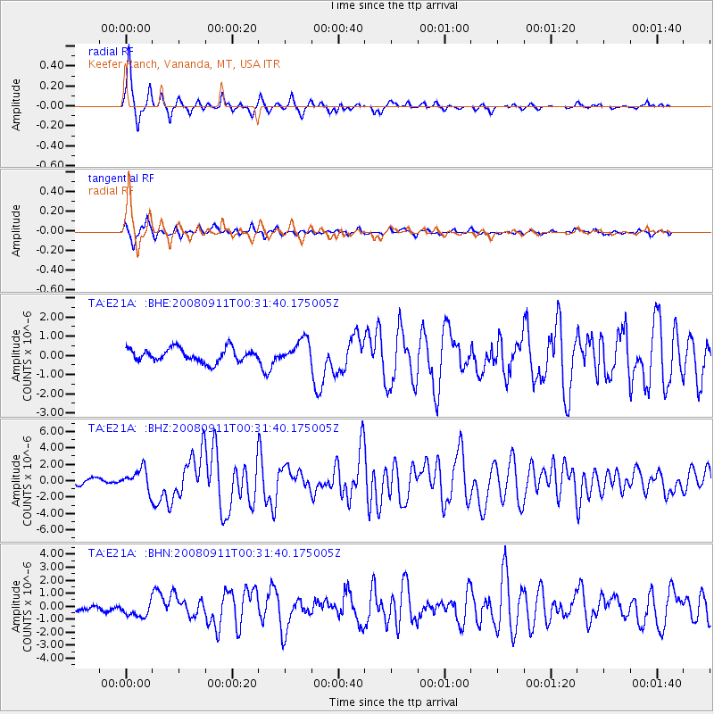
Signal To Noise
| Channel | StoN | STA | LTA |
| TA:E21A: :BHZ:20080911T00:31:40.175005Z | 3.6559575 | 1.3287857E-6 | 3.6345767E-7 |
| TA:E21A: :BHN:20080911T00:31:40.175005Z | 1.7141652 | 6.037062E-7 | 3.521867E-7 |
| TA:E21A: :BHE:20080911T00:31:40.175005Z | 1.7207876 | 6.018024E-7 | 3.4972496E-7 |
| Arrivals |
| Ps | 4.8 SECOND |
| PpPs | 19 SECOND |
| PsPs/PpSs | 24 SECOND |


