You are here: Home > Network List > TA - USArray Transportable Network (new EarthScope stations) Stations List
> Station E21A Keefer Ranch, Vananda, MT, USA > Earthquake Result Viewer
E21A Keefer Ranch, Vananda, MT, USA - Earthquake Result Viewer
| Earthquake location: |
Tonga Islands |
| Earthquake latitude/longitude: |
-20.8/-174.3 |
| Earthquake time(UTC): |
2009/07/30 (211) 20:05:34 GMT |
| Earthquake Depth: |
10 km |
| Earthquake Magnitude: |
5.9 MB, 5.7 MS, 5.8 MW, 5.7 MW |
| Earthquake Catalog/Contributor: |
WHDF/NEIC |
|
| Network: |
TA USArray Transportable Network (new EarthScope stations) |
| Station: |
E21A Keefer Ranch, Vananda, MT, USA |
| Lat/Lon: |
46.54 N/107.08 W |
| Elevation: |
834 m |
|
| Distance: |
90.3 deg |
| Az: |
39.512 deg |
| Baz: |
239.554 deg |
| Ray Param: |
0.041681834 |
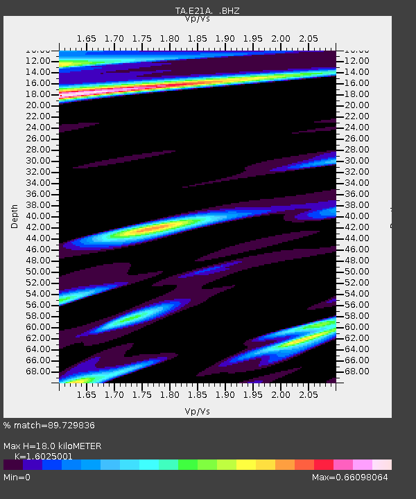
| Estimated Moho Depth: |
18.0 km |
| Estimated Crust Vp/Vs: |
1.60 |
| Assumed Crust Vp: |
6.438 km/s |
| Estimated Crust Vs: |
4.017 km/s |
| Estimated Crust Poisson's Ratio: |
0.18 |
|
| Radial Match: |
89.729836 % |
| Radial Bump: |
348 |
| Transverse Match: |
74.58842 % |
| Transverse Bump: |
262 |
| SOD ConfigId: |
2622 |
| Insert Time: |
2010-03-06 11:28:09.143 +0000 |
| GWidth: |
2.5 |
| Max Bumps: |
400 |
| Tol: |
0.001 |
|

Signal To Noise
| Channel | StoN | STA | LTA |
| TA:E21A: :BHZ:20090730T20:18:04.50001Z | 5.896522 | 3.622403E-7 | 6.143288E-8 |
| TA:E21A: :BHN:20090730T20:18:04.50001Z | 1.4396864 | 1.3145741E-7 | 9.130975E-8 |
| TA:E21A: :BHE:20090730T20:18:04.50001Z | 1.1515728 | 1.0431751E-7 | 9.058698E-8 |
| Arrivals |
| Ps | 1.7 SECOND |
| PpPs | 7.1 SECOND |
| PsPs/PpSs | 8.8 SECOND |


