You are here: Home > Network List > TA - USArray Transportable Network (new EarthScope stations) Stations List
> Station E21A Keefer Ranch, Vananda, MT, USA > Earthquake Result Viewer
E21A Keefer Ranch, Vananda, MT, USA - Earthquake Result Viewer
| Earthquake location: |
Southeast Of Honshu, Japan |
| Earthquake latitude/longitude: |
32.8/140.4 |
| Earthquake time(UTC): |
2009/08/12 (224) 22:48:51 GMT |
| Earthquake Depth: |
53 km |
| Earthquake Magnitude: |
6.2 MB, 6.6 MW, 6.6 MW |
| Earthquake Catalog/Contributor: |
WHDF/NEIC |
|
| Network: |
TA USArray Transportable Network (new EarthScope stations) |
| Station: |
E21A Keefer Ranch, Vananda, MT, USA |
| Lat/Lon: |
46.54 N/107.08 W |
| Elevation: |
834 m |
|
| Distance: |
80.4 deg |
| Az: |
40.296 deg |
| Baz: |
307.915 deg |
| Ray Param: |
0.048240148 |
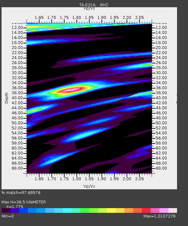
| Estimated Moho Depth: |
36.5 km |
| Estimated Crust Vp/Vs: |
1.77 |
| Assumed Crust Vp: |
6.438 km/s |
| Estimated Crust Vs: |
3.627 km/s |
| Estimated Crust Poisson's Ratio: |
0.27 |
|
| Radial Match: |
97.69576 % |
| Radial Bump: |
284 |
| Transverse Match: |
95.46767 % |
| Transverse Bump: |
352 |
| SOD ConfigId: |
2622 |
| Insert Time: |
2010-03-06 11:28:13.012 +0000 |
| GWidth: |
2.5 |
| Max Bumps: |
400 |
| Tol: |
0.001 |
|

Signal To Noise
| Channel | StoN | STA | LTA |
| TA:E21A: :BHZ:20090812T23:00:25.950029Z | 48.53454 | 3.3937254E-6 | 6.992392E-8 |
| TA:E21A: :BHN:20090812T23:00:25.950029Z | 7.2356386 | 9.981591E-7 | 1.3795038E-7 |
| TA:E21A: :BHE:20090812T23:00:25.950029Z | 8.1650505 | 1.1241156E-6 | 1.3767405E-7 |
| Arrivals |
| Ps | 4.5 SECOND |
| PpPs | 15 SECOND |
| PsPs/PpSs | 20 SECOND |


