You are here: Home > Network List > TA - USArray Transportable Network (new EarthScope stations) Stations List
> Station E21A Keefer Ranch, Vananda, MT, USA > Earthquake Result Viewer
E21A Keefer Ranch, Vananda, MT, USA - Earthquake Result Viewer
| Earthquake location: |
Southwestern Ryukyu Isl., Japan |
| Earthquake latitude/longitude: |
23.4/123.7 |
| Earthquake time(UTC): |
2009/08/17 (229) 10:15:05 GMT |
| Earthquake Depth: |
10 km |
| Earthquake Magnitude: |
5.7 MB |
| Earthquake Catalog/Contributor: |
WHDF/NEIC |
|
| Network: |
TA USArray Transportable Network (new EarthScope stations) |
| Station: |
E21A Keefer Ranch, Vananda, MT, USA |
| Lat/Lon: |
46.54 N/107.08 W |
| Elevation: |
834 m |
|
| Distance: |
96.6 deg |
| Az: |
32.574 deg |
| Baz: |
314.236 deg |
| Ray Param: |
0.04046713 |
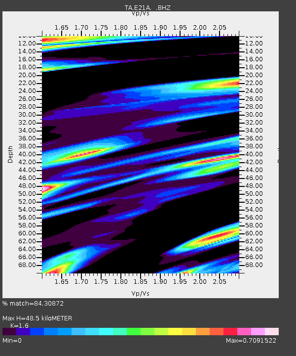
| Estimated Moho Depth: |
48.5 km |
| Estimated Crust Vp/Vs: |
1.60 |
| Assumed Crust Vp: |
6.438 km/s |
| Estimated Crust Vs: |
4.023 km/s |
| Estimated Crust Poisson's Ratio: |
0.18 |
|
| Radial Match: |
84.30872 % |
| Radial Bump: |
400 |
| Transverse Match: |
71.62443 % |
| Transverse Bump: |
400 |
| SOD ConfigId: |
2622 |
| Insert Time: |
2010-03-06 11:28:15.536 +0000 |
| GWidth: |
2.5 |
| Max Bumps: |
400 |
| Tol: |
0.001 |
|
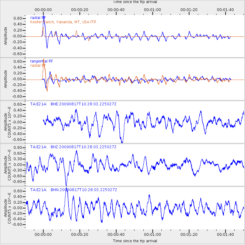
Signal To Noise
| Channel | StoN | STA | LTA |
| TA:E21A: :BHZ:20090817T10:28:03.225027Z | 1.0991206 | 3.167467E-7 | 2.8818195E-7 |
| TA:E21A: :BHN:20090817T10:28:03.225027Z | 1.3179146 | 2.204792E-7 | 1.6729399E-7 |
| TA:E21A: :BHE:20090817T10:28:03.225027Z | 2.0053005 | 2.7547367E-7 | 1.3737277E-7 |
| Arrivals |
| Ps | 4.6 SECOND |
| PpPs | 19 SECOND |
| PsPs/PpSs | 24 SECOND |


