You are here: Home > Network List > TA - USArray Transportable Network (new EarthScope stations) Stations List
> Station E21A Keefer Ranch, Vananda, MT, USA > Earthquake Result Viewer
E21A Keefer Ranch, Vananda, MT, USA - Earthquake Result Viewer

| Earthquake location: |
Samoa Islands Region |
| Earthquake latitude/longitude: |
-15.5/-172.1 |
| Earthquake time(UTC): |
2009/09/29 (272) 17:48:10 GMT |
| Earthquake Depth: |
18 km |
| Earthquake Magnitude: |
7.1 MB, 8.1 MS, 8.1 MW, 8.0 MW |
| Earthquake Catalog/Contributor: |
WHDF/NEIC |
|
| Network: |
TA USArray Transportable Network (new EarthScope stations) |
| Station: |
E21A Keefer Ranch, Vananda, MT, USA |
| Lat/Lon: |
46.54 N/107.08 W |
| Elevation: |
834 m |
|
| Distance: |
84.9 deg |
| Az: |
38.917 deg |
| Baz: |
241.334 deg |
| Ray Param: |
0.04514257 |
| Estimated Moho Depth: |
58.75 km |
| Estimated Crust Vp/Vs: |
2.09 |
| Assumed Crust Vp: |
6.438 km/s |
| Estimated Crust Vs: |
3.088 km/s |
| Estimated Crust Poisson's Ratio: |
0.35 |
|
| Radial Match: |
99.08394 % |
| Radial Bump: |
297 |
| Transverse Match: |
96.686195 % |
| Transverse Bump: |
400 |
| SOD ConfigId: |
2622 |
| Insert Time: |
2010-03-06 11:28:22.231 +0000 |
| GWidth: |
2.5 |
| Max Bumps: |
400 |
| Tol: |
0.001 |
|
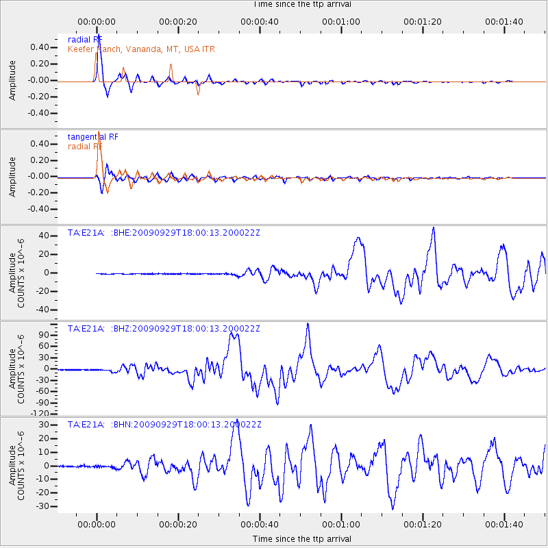
Signal To Noise
| Channel | StoN | STA | LTA |
| TA:E21A: :BHZ:20090929T18:00:13.200022Z | 11.849233 | 3.4269094E-6 | 2.892094E-7 |
| TA:E21A: :BHN:20090929T18:00:13.200022Z | 2.2249858 | 6.9026896E-7 | 3.102352E-7 |
| TA:E21A: :BHE:20090929T18:00:13.200022Z | 3.903841 | 1.0843802E-6 | 2.7777264E-7 |
| Arrivals |
| Ps | 10 SECOND |
| PpPs | 28 SECOND |
| PsPs/PpSs | 38 SECOND |


