You are here: Home > Network List > TA - USArray Transportable Network (new EarthScope stations) Stations List
> Station E21A Keefer Ranch, Vananda, MT, USA > Earthquake Result Viewer
E21A Keefer Ranch, Vananda, MT, USA - Earthquake Result Viewer
| Earthquake location: |
Ryukyu Islands, Japan |
| Earthquake latitude/longitude: |
29.2/129.8 |
| Earthquake time(UTC): |
2009/10/30 (303) 07:03:39 GMT |
| Earthquake Depth: |
34 km |
| Earthquake Magnitude: |
6.3 MB, 6.8 MS, 6.8 MW, 6.8 MW |
| Earthquake Catalog/Contributor: |
WHDF/NEIC |
|
| Network: |
TA USArray Transportable Network (new EarthScope stations) |
| Station: |
E21A Keefer Ranch, Vananda, MT, USA |
| Lat/Lon: |
46.54 N/107.08 W |
| Elevation: |
834 m |
|
| Distance: |
88.8 deg |
| Az: |
35.317 deg |
| Baz: |
312.936 deg |
| Ray Param: |
0.042295776 |
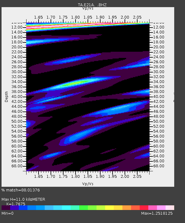
| Estimated Moho Depth: |
11.0 km |
| Estimated Crust Vp/Vs: |
1.77 |
| Assumed Crust Vp: |
6.438 km/s |
| Estimated Crust Vs: |
3.642 km/s |
| Estimated Crust Poisson's Ratio: |
0.26 |
|
| Radial Match: |
88.01376 % |
| Radial Bump: |
256 |
| Transverse Match: |
80.64297 % |
| Transverse Bump: |
366 |
| SOD ConfigId: |
2622 |
| Insert Time: |
2010-03-06 11:28:26.119 +0000 |
| GWidth: |
2.5 |
| Max Bumps: |
400 |
| Tol: |
0.001 |
|

Signal To Noise
| Channel | StoN | STA | LTA |
| TA:E21A: :BHZ:20091030T07:15:58.125005Z | 14.485901 | 2.2559288E-6 | 1.5573274E-7 |
| TA:E21A: :BHN:20091030T07:15:58.125005Z | 3.5046446 | 7.772052E-7 | 2.2176434E-7 |
| TA:E21A: :BHE:20091030T07:15:58.125005Z | 4.014358 | 1.1088756E-6 | 2.7622738E-7 |
| Arrivals |
| Ps | 1.3 SECOND |
| PpPs | 4.6 SECOND |
| PsPs/PpSs | 6.0 SECOND |


