You are here: Home > Network List > AV - Alaska Volcano Observatory Stations List
> Station SPCN Ckakachatna North Broadband, Mount Spurr, Alaska > Earthquake Result Viewer
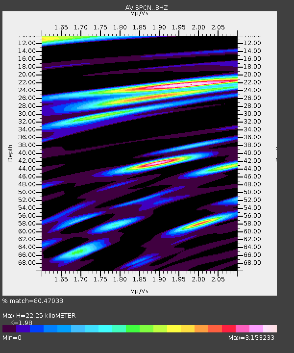
SPCN Ckakachatna North Broadband, Mount Spurr, Alaska - Earthquake Result Viewer
| Earthquake location: |
East Of Kuril Islands |
| Earthquake latitude/longitude: |
43.9/148.0 |
| Earthquake time(UTC): |
2018/06/02 (153) 09:48:08 GMT |
| Earthquake Depth: |
10 km |
| Earthquake Magnitude: |
5.5 Mww |
| Earthquake Catalog/Contributor: |
NEIC PDE/us |
|
| Network: |
AV Alaska Volcano Observatory |
| Station: |
SPCN Ckakachatna North Broadband, Mount Spurr, Alaska |
| Lat/Lon: |
61.22 N/152.19 W |
| Elevation: |
735 m |
|
| Distance: |
38.6 deg |
| Az: |
42.04 deg |
| Baz: |
271.503 deg |
| Ray Param: |
0.0754503 |
| Estimated Moho Depth: |
22.25 km |
| Estimated Crust Vp/Vs: |
1.98 |
| Assumed Crust Vp: |
6.566 km/s |
| Estimated Crust Vs: |
3.316 km/s |
| Estimated Crust Poisson's Ratio: |
0.33 |
|
| Radial Match: |
80.47038 % |
| Radial Bump: |
400 |
| Transverse Match: |
85.02754 % |
| Transverse Bump: |
400 |
| SOD ConfigId: |
13570011 |
| Insert Time: |
2019-04-30 07:59:17.629 +0000 |
| GWidth: |
2.5 |
| Max Bumps: |
400 |
| Tol: |
0.001 |
|

Signal To Noise
| Channel | StoN | STA | LTA |
| AV:SPCN: :BHZ:20180602T09:55:00.95899Z | 4.422444 | 6.937911E-7 | 1.5687955E-7 |
| AV:SPCN: :BHN:20180602T09:55:00.95899Z | 2.192704 | 6.2522383E-7 | 2.8513824E-7 |
| AV:SPCN: :BHE:20180602T09:55:00.95899Z | 1.6121266 | 4.6814174E-7 | 2.903877E-7 |
| Arrivals |
| Ps | 3.6 SECOND |
| PpPs | 9.4 SECOND |
| PsPs/PpSs | 13 SECOND |


