You are here: Home > Network List > TA - USArray Transportable Network (new EarthScope stations) Stations List
> Station E21A Keefer Ranch, Vananda, MT, USA > Earthquake Result Viewer
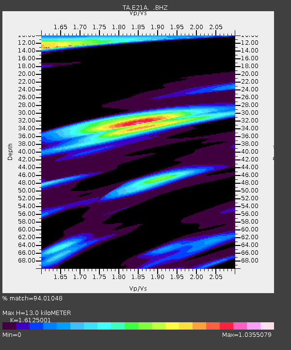
E21A Keefer Ranch, Vananda, MT, USA - Earthquake Result Viewer
| Earthquake location: |
Sea Of Okhotsk |
| Earthquake latitude/longitude: |
54.2/154.3 |
| Earthquake time(UTC): |
2008/11/24 (329) 09:02:58 GMT |
| Earthquake Depth: |
492 km |
| Earthquake Magnitude: |
6.5 MB, 7.3 MW, 7.3 MW |
| Earthquake Catalog/Contributor: |
WHDF/NEIC |
|
| Network: |
TA USArray Transportable Network (new EarthScope stations) |
| Station: |
E21A Keefer Ranch, Vananda, MT, USA |
| Lat/Lon: |
46.54 N/107.08 W |
| Elevation: |
834 m |
|
| Distance: |
58.3 deg |
| Az: |
53.305 deg |
| Baz: |
316.965 deg |
| Ray Param: |
0.060980413 |
| Estimated Moho Depth: |
13.0 km |
| Estimated Crust Vp/Vs: |
1.61 |
| Assumed Crust Vp: |
6.438 km/s |
| Estimated Crust Vs: |
3.992 km/s |
| Estimated Crust Poisson's Ratio: |
0.19 |
|
| Radial Match: |
94.01048 % |
| Radial Bump: |
271 |
| Transverse Match: |
87.42932 % |
| Transverse Bump: |
388 |
| SOD ConfigId: |
2658 |
| Insert Time: |
2010-03-06 11:28:32.989 +0000 |
| GWidth: |
2.5 |
| Max Bumps: |
400 |
| Tol: |
0.001 |
|

Signal To Noise
| Channel | StoN | STA | LTA |
| TA:E21A: :BHZ:20081124T09:11:35.150015Z | 22.068998 | 7.3251126E-6 | 3.3191867E-7 |
| TA:E21A: :BHN:20081124T09:11:35.150015Z | 2.5114145 | 1.8456174E-6 | 7.3489156E-7 |
| TA:E21A: :BHE:20081124T09:11:35.150015Z | 2.2623084 | 1.1742222E-6 | 5.190372E-7 |
| Arrivals |
| Ps | 1.3 SECOND |
| PpPs | 5.0 SECOND |
| PsPs/PpSs | 6.3 SECOND |


