You are here: Home > Network List > CI - Caltech Regional Seismic Network Stations List
> Station MPM Manuel Prospect Mine, California, USA > Earthquake Result Viewer
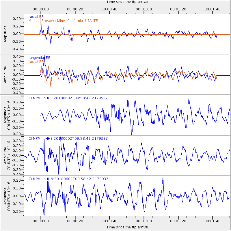
MPM Manuel Prospect Mine, California, USA - Earthquake Result Viewer
*The percent match for this event was below the threshold and hence no stack was calculated.
| Earthquake location: |
East Of Kuril Islands |
| Earthquake latitude/longitude: |
43.9/148.0 |
| Earthquake time(UTC): |
2018/06/02 (153) 09:48:08 GMT |
| Earthquake Depth: |
10 km |
| Earthquake Magnitude: |
5.5 Mww |
| Earthquake Catalog/Contributor: |
NEIC PDE/us |
|
| Network: |
CI Caltech Regional Seismic Network |
| Station: |
MPM Manuel Prospect Mine, California, USA |
| Lat/Lon: |
36.06 N/117.49 W |
| Elevation: |
185 m |
|
| Distance: |
68.9 deg |
| Az: |
59.972 deg |
| Baz: |
309.487 deg |
| Ray Param: |
$rayparam |
*The percent match for this event was below the threshold and hence was not used in the summary stack. |
|
| Radial Match: |
53.72504 % |
| Radial Bump: |
400 |
| Transverse Match: |
63.91262 % |
| Transverse Bump: |
400 |
| SOD ConfigId: |
13570011 |
| Insert Time: |
2019-04-30 08:00:23.486 +0000 |
| GWidth: |
2.5 |
| Max Bumps: |
400 |
| Tol: |
0.001 |
|
Signal To Noise
| Channel | StoN | STA | LTA |
| CI:MPM: :HHZ:20180602T09:58:42.217993Z | 2.9622061 | 1.7474368E-7 | 5.899106E-8 |
| CI:MPM: :HHN:20180602T09:58:42.217993Z | 1.9263259 | 1.16013844E-7 | 6.022545E-8 |
| CI:MPM: :HHE:20180602T09:58:42.217993Z | 1.4530584 | 7.1010724E-8 | 4.8869836E-8 |
| Arrivals |
| Ps | |
| PpPs | |
| PsPs/PpSs | |


