You are here: Home > Network List > TA - USArray Transportable Network (new EarthScope stations) Stations List
> Station E21A Keefer Ranch, Vananda, MT, USA > Earthquake Result Viewer
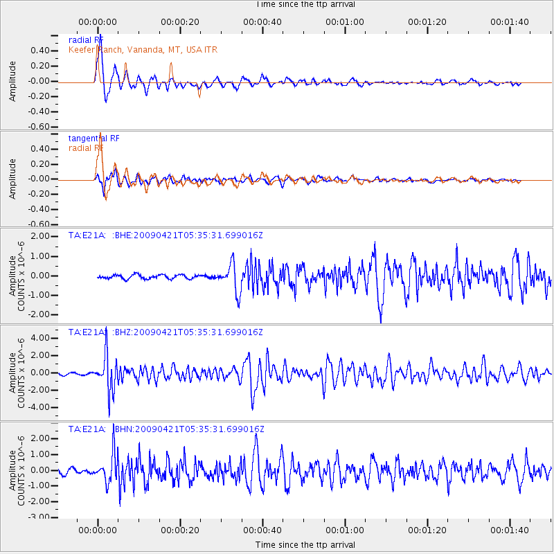
E21A Keefer Ranch, Vananda, MT, USA - Earthquake Result Viewer
| Earthquake location: |
Kuril Islands |
| Earthquake latitude/longitude: |
50.8/155.0 |
| Earthquake time(UTC): |
2009/04/21 (111) 05:26:11 GMT |
| Earthquake Depth: |
152 km |
| Earthquake Magnitude: |
6.0 MB, 6.2 MW, 6.2 MW |
| Earthquake Catalog/Contributor: |
WHDF/NEIC |
|
| Network: |
TA USArray Transportable Network (new EarthScope stations) |
| Station: |
E21A Keefer Ranch, Vananda, MT, USA |
| Lat/Lon: |
46.54 N/107.08 W |
| Elevation: |
834 m |
|
| Distance: |
60.1 deg |
| Az: |
52.095 deg |
| Baz: |
313.542 deg |
| Ray Param: |
0.061315488 |
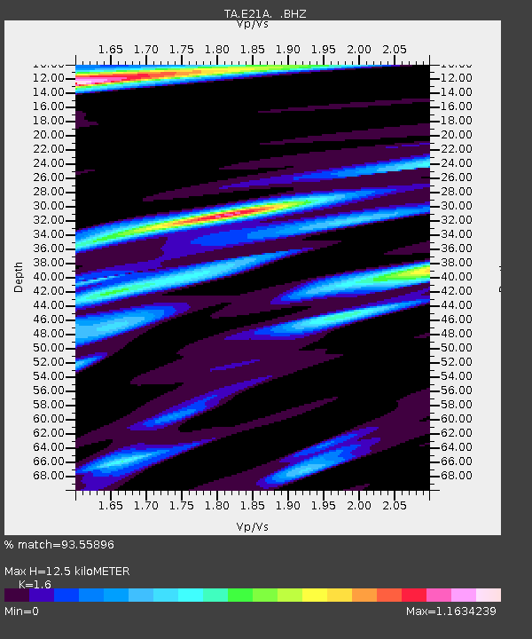
| Estimated Moho Depth: |
12.5 km |
| Estimated Crust Vp/Vs: |
1.60 |
| Assumed Crust Vp: |
6.438 km/s |
| Estimated Crust Vs: |
4.023 km/s |
| Estimated Crust Poisson's Ratio: |
0.18 |
|
| Radial Match: |
93.55896 % |
| Radial Bump: |
337 |
| Transverse Match: |
76.5447 % |
| Transverse Bump: |
400 |
| SOD ConfigId: |
2658 |
| Insert Time: |
2010-03-06 11:28:46.385 +0000 |
| GWidth: |
2.5 |
| Max Bumps: |
400 |
| Tol: |
0.001 |
|
Signal To Noise
| Channel | StoN | STA | LTA |
| TA:E21A: :BHZ:20090421T05:35:31.699016Z | 15.185003 | 2.0790853E-6 | 1.3691701E-7 |
| TA:E21A: :BHN:20090421T05:35:31.699016Z | 5.841529 | 9.268503E-7 | 1.5866571E-7 |
| TA:E21A: :BHE:20090421T05:35:31.699016Z | 7.2960105 | 7.3513127E-7 | 1.0075798E-7 |
| Arrivals |
| Ps | 1.2 SECOND |
| PpPs | 4.8 SECOND |
| PsPs/PpSs | 6.0 SECOND |


