You are here: Home > Network List > TA - USArray Transportable Network (new EarthScope stations) Stations List
> Station E21A Keefer Ranch, Vananda, MT, USA > Earthquake Result Viewer
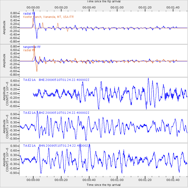
E21A Keefer Ranch, Vananda, MT, USA - Earthquake Result Viewer
| Earthquake location: |
Off Coast Of Ecuador |
| Earthquake latitude/longitude: |
1.4/-85.2 |
| Earthquake time(UTC): |
2009/05/10 (130) 01:16:06 GMT |
| Earthquake Depth: |
6.0 km |
| Earthquake Magnitude: |
5.5 MB, 5.7 MS, 6.1 MW, 6.1 MW |
| Earthquake Catalog/Contributor: |
WHDF/NEIC |
|
| Network: |
TA USArray Transportable Network (new EarthScope stations) |
| Station: |
E21A Keefer Ranch, Vananda, MT, USA |
| Lat/Lon: |
46.54 N/107.08 W |
| Elevation: |
834 m |
|
| Distance: |
48.9 deg |
| Az: |
340.008 deg |
| Baz: |
150.32 deg |
| Ray Param: |
0.06908091 |
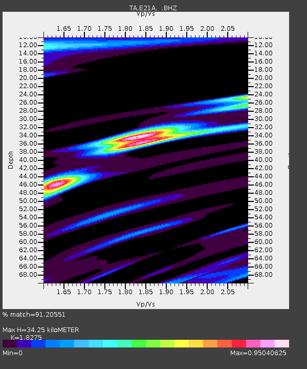
| Estimated Moho Depth: |
34.25 km |
| Estimated Crust Vp/Vs: |
1.83 |
| Assumed Crust Vp: |
6.438 km/s |
| Estimated Crust Vs: |
3.523 km/s |
| Estimated Crust Poisson's Ratio: |
0.29 |
|
| Radial Match: |
91.20551 % |
| Radial Bump: |
259 |
| Transverse Match: |
75.95407 % |
| Transverse Bump: |
324 |
| SOD ConfigId: |
2760 |
| Insert Time: |
2010-03-06 11:29:06.897 +0000 |
| GWidth: |
2.5 |
| Max Bumps: |
400 |
| Tol: |
0.001 |
|
Signal To Noise
| Channel | StoN | STA | LTA |
| TA:E21A: :BHZ:20090510T01:24:22.400002Z | 7.4546695 | 5.31458E-7 | 7.129196E-8 |
| TA:E21A: :BHN:20090510T01:24:22.400002Z | 3.8288543 | 3.5507165E-7 | 9.2735746E-8 |
| TA:E21A: :BHE:20090510T01:24:22.400002Z | 1.846535 | 1.9244041E-7 | 1.04217044E-7 |
| Arrivals |
| Ps | 4.7 SECOND |
| PpPs | 14 SECOND |
| PsPs/PpSs | 19 SECOND |


