You are here: Home > Network List > TA - USArray Transportable Network (new EarthScope stations) Stations List
> Station E21A Keefer Ranch, Vananda, MT, USA > Earthquake Result Viewer
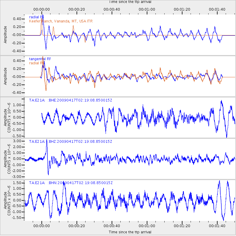
E21A Keefer Ranch, Vananda, MT, USA - Earthquake Result Viewer
*The percent match for this event was below the threshold and hence no stack was calculated.
| Earthquake location: |
Near Coast Of Northern Chile |
| Earthquake latitude/longitude: |
-19.6/-70.5 |
| Earthquake time(UTC): |
2009/04/17 (107) 02:08:08 GMT |
| Earthquake Depth: |
25 km |
| Earthquake Magnitude: |
5.8 MB, 5.8 MS, 6.1 MW, 6.1 MW |
| Earthquake Catalog/Contributor: |
WHDF/NEIC |
|
| Network: |
TA USArray Transportable Network (new EarthScope stations) |
| Station: |
E21A Keefer Ranch, Vananda, MT, USA |
| Lat/Lon: |
46.54 N/107.08 W |
| Elevation: |
834 m |
|
| Distance: |
73.7 deg |
| Az: |
334.607 deg |
| Baz: |
144.145 deg |
| Ray Param: |
$rayparam |
*The percent match for this event was below the threshold and hence was not used in the summary stack. |
|
| Radial Match: |
67.09885 % |
| Radial Bump: |
336 |
| Transverse Match: |
60.9147 % |
| Transverse Bump: |
382 |
| SOD ConfigId: |
2658 |
| Insert Time: |
2010-03-06 11:29:26.990 +0000 |
| GWidth: |
2.5 |
| Max Bumps: |
400 |
| Tol: |
0.001 |
|
Signal To Noise
| Channel | StoN | STA | LTA |
| TA:E21A: :BHZ:20090417T02:19:08.850015Z | 7.5170364 | 1.2509298E-6 | 1.6641263E-7 |
| TA:E21A: :BHN:20090417T02:19:08.850015Z | 2.2445862 | 5.457313E-7 | 2.4313226E-7 |
| TA:E21A: :BHE:20090417T02:19:08.850015Z | 1.2638407 | 3.6843036E-7 | 2.9151647E-7 |
| Arrivals |
| Ps | |
| PpPs | |
| PsPs/PpSs | |


