You are here: Home > Network List > TA - USArray Transportable Network (new EarthScope stations) Stations List
> Station E21A Keefer Ranch, Vananda, MT, USA > Earthquake Result Viewer
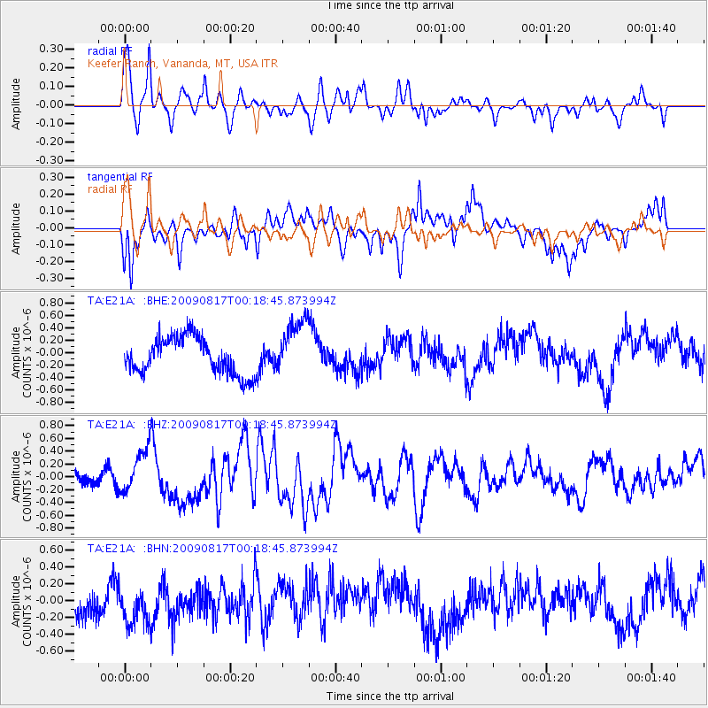
E21A Keefer Ranch, Vananda, MT, USA - Earthquake Result Viewer
*The percent match for this event was below the threshold and hence no stack was calculated.
| Earthquake location: |
Southwestern Ryukyu Isl., Japan |
| Earthquake latitude/longitude: |
23.5/123.5 |
| Earthquake time(UTC): |
2009/08/17 (229) 00:05:49 GMT |
| Earthquake Depth: |
20 km |
| Earthquake Magnitude: |
6.2 MB, 6.6 MS, 6.7 MW, 6.6 MW |
| Earthquake Catalog/Contributor: |
WHDF/NEIC |
|
| Network: |
TA USArray Transportable Network (new EarthScope stations) |
| Station: |
E21A Keefer Ranch, Vananda, MT, USA |
| Lat/Lon: |
46.54 N/107.08 W |
| Elevation: |
834 m |
|
| Distance: |
96.6 deg |
| Az: |
32.466 deg |
| Baz: |
314.446 deg |
| Ray Param: |
$rayparam |
*The percent match for this event was below the threshold and hence was not used in the summary stack. |
|
| Radial Match: |
56.71074 % |
| Radial Bump: |
400 |
| Transverse Match: |
65.50091 % |
| Transverse Bump: |
400 |
| SOD ConfigId: |
2622 |
| Insert Time: |
2010-03-06 11:29:34.562 +0000 |
| GWidth: |
2.5 |
| Max Bumps: |
400 |
| Tol: |
0.001 |
|
Signal To Noise
| Channel | StoN | STA | LTA |
| TA:E21A: :BHZ:20090817T00:18:45.873994Z | 3.932821 | 3.3743905E-7 | 8.5800764E-8 |
| TA:E21A: :BHN:20090817T00:18:45.873994Z | 1.3295467 | 2.4524513E-7 | 1.8445769E-7 |
| TA:E21A: :BHE:20090817T00:18:45.873994Z | 1.5782161 | 4.6596494E-7 | 2.9524787E-7 |
| Arrivals |
| Ps | |
| PpPs | |
| PsPs/PpSs | |


