You are here: Home > Network List > TA - USArray Transportable Network (new EarthScope stations) Stations List
> Station E21A Keefer Ranch, Vananda, MT, USA > Earthquake Result Viewer
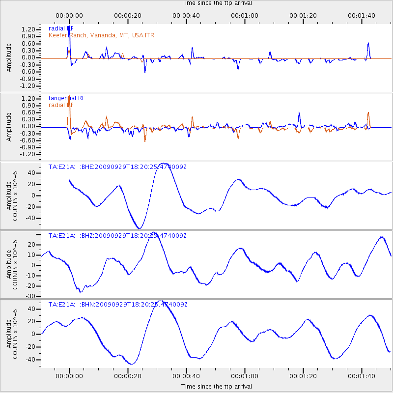
E21A Keefer Ranch, Vananda, MT, USA - Earthquake Result Viewer
*The percent match for this event was below the threshold and hence no stack was calculated.
| Earthquake location: |
Samoa Islands Region |
| Earthquake latitude/longitude: |
-15.6/-172.0 |
| Earthquake time(UTC): |
2009/09/29 (272) 18:08:21 GMT |
| Earthquake Depth: |
10 km |
| Earthquake Magnitude: |
5.6 MB |
| Earthquake Catalog/Contributor: |
WHDF/NEIC |
|
| Network: |
TA USArray Transportable Network (new EarthScope stations) |
| Station: |
E21A Keefer Ranch, Vananda, MT, USA |
| Lat/Lon: |
46.54 N/107.08 W |
| Elevation: |
834 m |
|
| Distance: |
84.9 deg |
| Az: |
38.886 deg |
| Baz: |
241.231 deg |
| Ray Param: |
$rayparam |
*The percent match for this event was below the threshold and hence was not used in the summary stack. |
|
| Radial Match: |
42.49236 % |
| Radial Bump: |
369 |
| Transverse Match: |
53.457127 % |
| Transverse Bump: |
391 |
| SOD ConfigId: |
2622 |
| Insert Time: |
2010-03-06 11:29:42.485 +0000 |
| GWidth: |
2.5 |
| Max Bumps: |
400 |
| Tol: |
0.001 |
|
Signal To Noise
| Channel | StoN | STA | LTA |
| TA:E21A: :BHZ:20090929T18:20:25.474009Z | 1.3637934 | 1.973871E-5 | 1.4473388E-5 |
| TA:E21A: :BHN:20090929T18:20:25.474009Z | 1.5136651 | 2.5770807E-5 | 1.7025437E-5 |
| TA:E21A: :BHE:20090929T18:20:25.474009Z | 2.6668146 | 5.9420498E-5 | 2.228145E-5 |
| Arrivals |
| Ps | |
| PpPs | |
| PsPs/PpSs | |


