You are here: Home > Network List > TA - USArray Transportable Network (new EarthScope stations) Stations List
> Station D20K Etivluk River, AK, USA > Earthquake Result Viewer
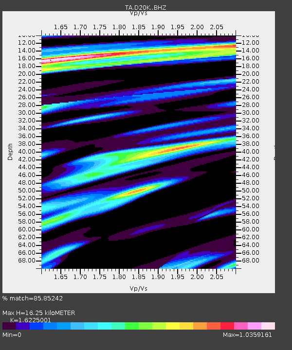
D20K Etivluk River, AK, USA - Earthquake Result Viewer
| Earthquake location: |
East Of Kuril Islands |
| Earthquake latitude/longitude: |
43.9/148.0 |
| Earthquake time(UTC): |
2018/06/02 (153) 09:48:08 GMT |
| Earthquake Depth: |
10 km |
| Earthquake Magnitude: |
5.5 Mww |
| Earthquake Catalog/Contributor: |
NEIC PDE/us |
|
| Network: |
TA USArray Transportable Network (new EarthScope stations) |
| Station: |
D20K Etivluk River, AK, USA |
| Lat/Lon: |
68.71 N/156.61 W |
| Elevation: |
577 m |
|
| Distance: |
37.5 deg |
| Az: |
29.596 deg |
| Baz: |
257.671 deg |
| Ray Param: |
0.07612508 |
| Estimated Moho Depth: |
16.25 km |
| Estimated Crust Vp/Vs: |
1.62 |
| Assumed Crust Vp: |
6.221 km/s |
| Estimated Crust Vs: |
3.834 km/s |
| Estimated Crust Poisson's Ratio: |
0.19 |
|
| Radial Match: |
85.85242 % |
| Radial Bump: |
400 |
| Transverse Match: |
78.36722 % |
| Transverse Bump: |
400 |
| SOD ConfigId: |
13570011 |
| Insert Time: |
2019-04-30 08:06:54.275 +0000 |
| GWidth: |
2.5 |
| Max Bumps: |
400 |
| Tol: |
0.001 |
|

Signal To Noise
| Channel | StoN | STA | LTA |
| TA:D20K: :BHZ:20180602T09:54:50.975012Z | 5.7234077 | 5.675977E-7 | 9.917129E-8 |
| TA:D20K: :BHN:20180602T09:54:50.975012Z | 1.8614591 | 9.015884E-8 | 4.84345E-8 |
| TA:D20K: :BHE:20180602T09:54:50.975012Z | 4.645441 | 2.4999437E-7 | 5.381499E-8 |
| Arrivals |
| Ps | 1.8 SECOND |
| PpPs | 6.4 SECOND |
| PsPs/PpSs | 8.1 SECOND |


