You are here: Home > Network List > TA - USArray Transportable Network (new EarthScope stations) Stations List
> Station E21A Keefer Ranch, Vananda, MT, USA > Earthquake Result Viewer
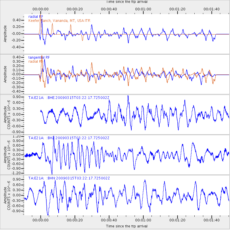
E21A Keefer Ranch, Vananda, MT, USA - Earthquake Result Viewer
*The percent match for this event was below the threshold and hence no stack was calculated.
| Earthquake location: |
Galapagos Islands Region |
| Earthquake latitude/longitude: |
2.4/-95.1 |
| Earthquake time(UTC): |
2009/03/15 (074) 03:14:31 GMT |
| Earthquake Depth: |
10 km |
| Earthquake Magnitude: |
5.5 MS, 5.4 MB, 5.8 MW, 5.8 MW |
| Earthquake Catalog/Contributor: |
WHDF/NEIC |
|
| Network: |
TA USArray Transportable Network (new EarthScope stations) |
| Station: |
E21A Keefer Ranch, Vananda, MT, USA |
| Lat/Lon: |
46.54 N/107.08 W |
| Elevation: |
834 m |
|
| Distance: |
45.2 deg |
| Az: |
348.369 deg |
| Baz: |
163.034 deg |
| Ray Param: |
$rayparam |
*The percent match for this event was below the threshold and hence was not used in the summary stack. |
|
| Radial Match: |
50.449993 % |
| Radial Bump: |
303 |
| Transverse Match: |
66.41096 % |
| Transverse Bump: |
388 |
| SOD ConfigId: |
2658 |
| Insert Time: |
2010-03-06 11:30:14.326 +0000 |
| GWidth: |
2.5 |
| Max Bumps: |
400 |
| Tol: |
0.001 |
|
Signal To Noise
| Channel | StoN | STA | LTA |
| TA:E21A: :BHZ:20090315T03:22:17.725002Z | 5.0455604 | 3.8529828E-7 | 7.636383E-8 |
| TA:E21A: :BHN:20090315T03:22:17.725002Z | 2.8297465 | 5.937161E-7 | 2.0981247E-7 |
| TA:E21A: :BHE:20090315T03:22:17.725002Z | 0.68598676 | 1.6877509E-7 | 2.4603256E-7 |
| Arrivals |
| Ps | |
| PpPs | |
| PsPs/PpSs | |


