You are here: Home > Network List > TA - USArray Transportable Network (new EarthScope stations) Stations List
> Station K15K Wolf Creek Mountain, AK, USA > Earthquake Result Viewer
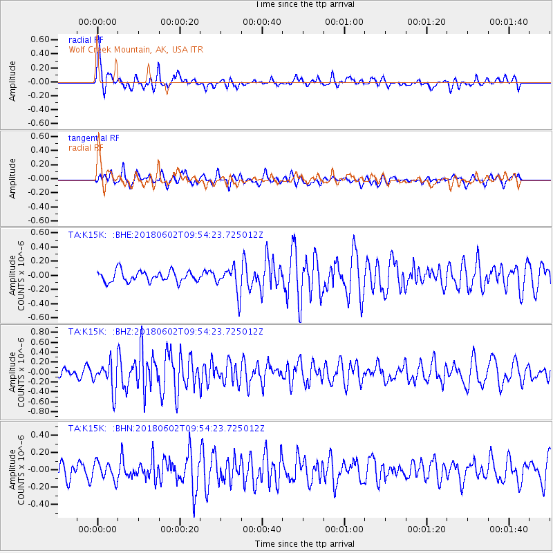
K15K Wolf Creek Mountain, AK, USA - Earthquake Result Viewer
*The percent match for this event was below the threshold and hence no stack was calculated.
| Earthquake location: |
East Of Kuril Islands |
| Earthquake latitude/longitude: |
43.9/148.0 |
| Earthquake time(UTC): |
2018/06/02 (153) 09:48:08 GMT |
| Earthquake Depth: |
10 km |
| Earthquake Magnitude: |
5.5 Mww |
| Earthquake Catalog/Contributor: |
NEIC PDE/us |
|
| Network: |
TA USArray Transportable Network (new EarthScope stations) |
| Station: |
K15K Wolf Creek Mountain, AK, USA |
| Lat/Lon: |
62.29 N/161.53 W |
| Elevation: |
346 m |
|
| Distance: |
34.3 deg |
| Az: |
39.784 deg |
| Baz: |
261.462 deg |
| Ray Param: |
$rayparam |
*The percent match for this event was below the threshold and hence was not used in the summary stack. |
|
| Radial Match: |
74.465454 % |
| Radial Bump: |
400 |
| Transverse Match: |
72.69377 % |
| Transverse Bump: |
400 |
| SOD ConfigId: |
13570011 |
| Insert Time: |
2019-04-30 08:07:57.867 +0000 |
| GWidth: |
2.5 |
| Max Bumps: |
400 |
| Tol: |
0.001 |
|
Signal To Noise
| Channel | StoN | STA | LTA |
| TA:K15K: :BHZ:20180602T09:54:23.725012Z | 4.322217 | 3.0486746E-7 | 7.053497E-8 |
| TA:K15K: :BHN:20180602T09:54:23.725012Z | 0.85605145 | 1.0339711E-7 | 1.2078377E-7 |
| TA:K15K: :BHE:20180602T09:54:23.725012Z | 2.489913 | 1.906541E-7 | 7.6570586E-8 |
| Arrivals |
| Ps | |
| PpPs | |
| PsPs/PpSs | |


