You are here: Home > Network List > TA - USArray Transportable Network (new EarthScope stations) Stations List
> Station M17K Holitna River, AK, USA > Earthquake Result Viewer
M17K Holitna River, AK, USA - Earthquake Result Viewer
| Earthquake location: |
East Of Kuril Islands |
| Earthquake latitude/longitude: |
43.9/148.0 |
| Earthquake time(UTC): |
2018/06/02 (153) 09:48:08 GMT |
| Earthquake Depth: |
10 km |
| Earthquake Magnitude: |
5.5 Mww |
| Earthquake Catalog/Contributor: |
NEIC PDE/us |
|
| Network: |
TA USArray Transportable Network (new EarthScope stations) |
| Station: |
M17K Holitna River, AK, USA |
| Lat/Lon: |
61.40 N/157.44 W |
| Elevation: |
387 m |
|
| Distance: |
36.1 deg |
| Az: |
41.68 deg |
| Baz: |
266.616 deg |
| Ray Param: |
0.07686429 |
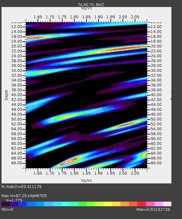
| Estimated Moho Depth: |
67.25 km |
| Estimated Crust Vp/Vs: |
1.77 |
| Assumed Crust Vp: |
6.155 km/s |
| Estimated Crust Vs: |
3.468 km/s |
| Estimated Crust Poisson's Ratio: |
0.27 |
|
| Radial Match: |
83.411125 % |
| Radial Bump: |
400 |
| Transverse Match: |
80.896515 % |
| Transverse Bump: |
400 |
| SOD ConfigId: |
13570011 |
| Insert Time: |
2019-04-30 08:08:12.812 +0000 |
| GWidth: |
2.5 |
| Max Bumps: |
400 |
| Tol: |
0.001 |
|

Signal To Noise
| Channel | StoN | STA | LTA |
| TA:M17K: :BHZ:20180602T09:54:39.549994Z | 7.0688024 | 3.8247606E-7 | 5.410762E-8 |
| TA:M17K: :BHN:20180602T09:54:39.549994Z | 1.5979003 | 1.2814812E-7 | 8.019782E-8 |
| TA:M17K: :BHE:20180602T09:54:39.549994Z | 2.549391 | 2.1139986E-7 | 8.292171E-8 |
| Arrivals |
| Ps | 9.1 SECOND |
| PpPs | 28 SECOND |
| PsPs/PpSs | 37 SECOND |


