You are here: Home > Network List > TA - USArray Transportable Network (new EarthScope stations) Stations List
> Station F21A Absaloka Mine, Hardin, MT, USA > Earthquake Result Viewer
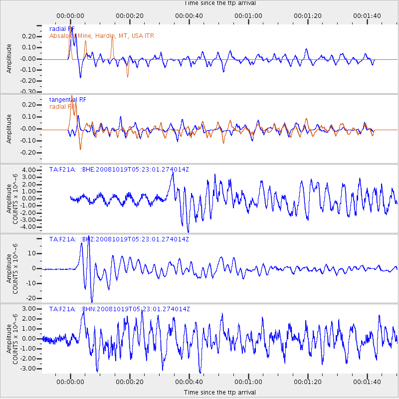
F21A Absaloka Mine, Hardin, MT, USA - Earthquake Result Viewer
| Earthquake location: |
Tonga Islands |
| Earthquake latitude/longitude: |
-21.9/-173.8 |
| Earthquake time(UTC): |
2008/10/19 (293) 05:10:33 GMT |
| Earthquake Depth: |
29 km |
| Earthquake Magnitude: |
6.8 MB, 7.0 MS, 6.9 MW, 6.9 MW |
| Earthquake Catalog/Contributor: |
WHDF/NEIC |
|
| Network: |
TA USArray Transportable Network (new EarthScope stations) |
| Station: |
F21A Absaloka Mine, Hardin, MT, USA |
| Lat/Lon: |
45.82 N/107.12 W |
| Elevation: |
1026 m |
|
| Distance: |
90.4 deg |
| Az: |
39.96 deg |
| Baz: |
238.559 deg |
| Ray Param: |
0.041669995 |
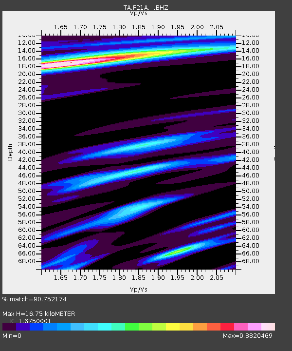
| Estimated Moho Depth: |
16.75 km |
| Estimated Crust Vp/Vs: |
1.68 |
| Assumed Crust Vp: |
6.178 km/s |
| Estimated Crust Vs: |
3.689 km/s |
| Estimated Crust Poisson's Ratio: |
0.22 |
|
| Radial Match: |
90.752174 % |
| Radial Bump: |
386 |
| Transverse Match: |
82.18505 % |
| Transverse Bump: |
400 |
| SOD ConfigId: |
2556 |
| Insert Time: |
2010-03-06 11:30:43.187 +0000 |
| GWidth: |
2.5 |
| Max Bumps: |
400 |
| Tol: |
0.001 |
|
Signal To Noise
| Channel | StoN | STA | LTA |
| TA:F21A: :BHZ:20081019T05:23:01.274014Z | 25.659943 | 6.8140453E-6 | 2.6555185E-7 |
| TA:F21A: :BHN:20081019T05:23:01.274014Z | 4.3991137 | 1.1971405E-6 | 2.721322E-7 |
| TA:F21A: :BHE:20081019T05:23:01.274014Z | 3.298543 | 1.5245957E-6 | 4.6220276E-7 |
| Arrivals |
| Ps | 1.9 SECOND |
| PpPs | 7.1 SECOND |
| PsPs/PpSs | 9.0 SECOND |


