You are here: Home > Network List > TA - USArray Transportable Network (new EarthScope stations) Stations List
> Station F21A Absaloka Mine, Hardin, MT, USA > Earthquake Result Viewer
F21A Absaloka Mine, Hardin, MT, USA - Earthquake Result Viewer
| Earthquake location: |
Off Coast Of Costa Rica |
| Earthquake latitude/longitude: |
7.9/-85.6 |
| Earthquake time(UTC): |
2009/08/13 (225) 09:37:35 GMT |
| Earthquake Depth: |
10 km |
| Earthquake Magnitude: |
5.8 MW, 5.3 MB |
| Earthquake Catalog/Contributor: |
WHDF/NEIC |
|
| Network: |
TA USArray Transportable Network (new EarthScope stations) |
| Station: |
F21A Absaloka Mine, Hardin, MT, USA |
| Lat/Lon: |
45.82 N/107.12 W |
| Elevation: |
1026 m |
|
| Distance: |
42.0 deg |
| Az: |
337.507 deg |
| Baz: |
147.187 deg |
| Ray Param: |
0.07340962 |
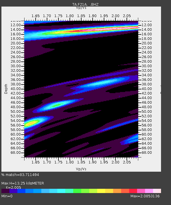
| Estimated Moho Depth: |
13.25 km |
| Estimated Crust Vp/Vs: |
2.01 |
| Assumed Crust Vp: |
6.178 km/s |
| Estimated Crust Vs: |
3.081 km/s |
| Estimated Crust Poisson's Ratio: |
0.33 |
|
| Radial Match: |
83.711494 % |
| Radial Bump: |
400 |
| Transverse Match: |
63.442703 % |
| Transverse Bump: |
400 |
| SOD ConfigId: |
2622 |
| Insert Time: |
2010-03-06 11:30:57.076 +0000 |
| GWidth: |
2.5 |
| Max Bumps: |
400 |
| Tol: |
0.001 |
|
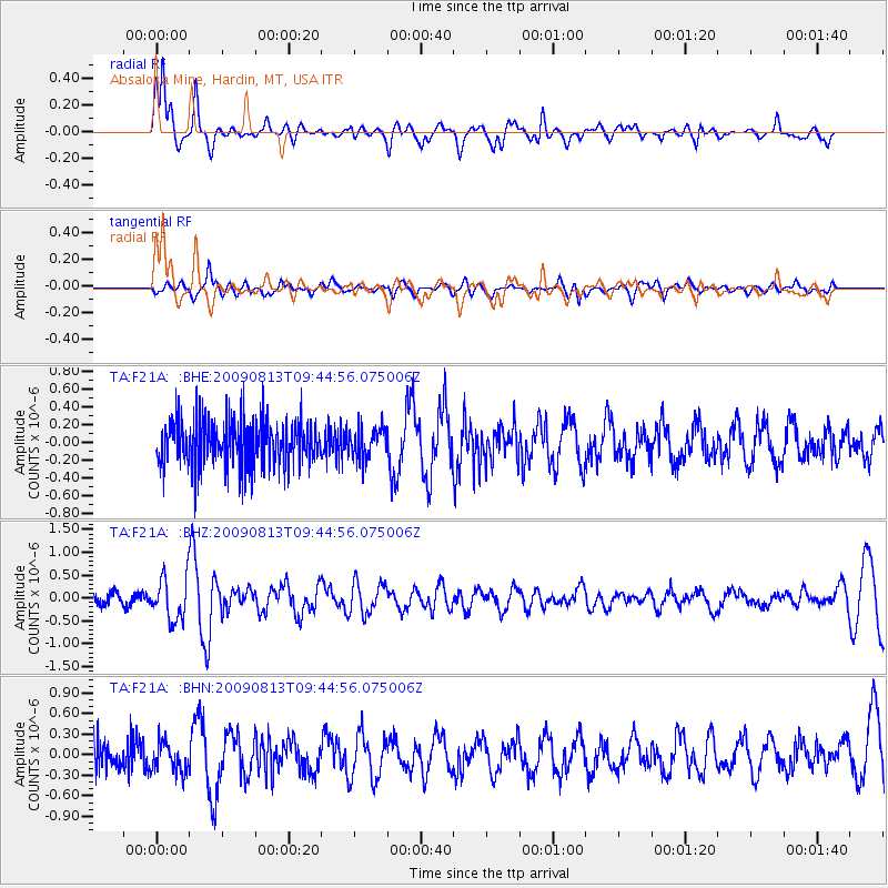
Signal To Noise
| Channel | StoN | STA | LTA |
| TA:F21A: :BHZ:20090813T09:44:56.075006Z | 4.095994 | 4.6767735E-7 | 1.1417921E-7 |
| TA:F21A: :BHN:20090813T09:44:56.075006Z | 0.8117858 | 2.1404527E-7 | 2.636721E-7 |
| TA:F21A: :BHE:20090813T09:44:56.075006Z | 0.6407695 | 1.6706116E-7 | 2.607196E-7 |
| Arrivals |
| Ps | 2.3 SECOND |
| PpPs | 6.1 SECOND |
| PsPs/PpSs | 8.4 SECOND |


