You are here: Home > Network List > TA - USArray Transportable Network (new EarthScope stations) Stations List
> Station F21A Absaloka Mine, Hardin, MT, USA > Earthquake Result Viewer
F21A Absaloka Mine, Hardin, MT, USA - Earthquake Result Viewer
| Earthquake location: |
Kermadec Islands Region |
| Earthquake latitude/longitude: |
-27.4/-176.3 |
| Earthquake time(UTC): |
2009/02/18 (049) 21:53:45 GMT |
| Earthquake Depth: |
25 km |
| Earthquake Magnitude: |
6.8 MB, 7.2 MS, 6.9 MW, 6.9 MW |
| Earthquake Catalog/Contributor: |
WHDF/NEIC |
|
| Network: |
TA USArray Transportable Network (new EarthScope stations) |
| Station: |
F21A Absaloka Mine, Hardin, MT, USA |
| Lat/Lon: |
45.82 N/107.12 W |
| Elevation: |
1026 m |
|
| Distance: |
96.1 deg |
| Az: |
41.109 deg |
| Baz: |
236.696 deg |
| Ray Param: |
0.040588614 |
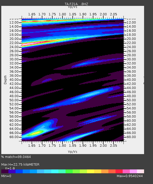
| Estimated Moho Depth: |
22.75 km |
| Estimated Crust Vp/Vs: |
1.60 |
| Assumed Crust Vp: |
6.178 km/s |
| Estimated Crust Vs: |
3.861 km/s |
| Estimated Crust Poisson's Ratio: |
0.18 |
|
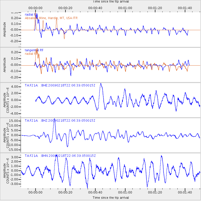
| Radial Match: |
89.0464 % |
| Radial Bump: |
400 |
| Transverse Match: |
75.4913 % |
| Transverse Bump: |
358 |
| SOD ConfigId: |
2658 |
| Insert Time: |
2010-03-06 11:31:11.070 +0000 |
| GWidth: |
2.5 |
| Max Bumps: |
400 |
| Tol: |
0.001 |
|
Signal To Noise
| Channel | StoN | STA | LTA |
| TA:F21A: :BHZ:20090218T22:06:39.050015Z | 2.9325469 | 1.0820405E-6 | 3.6897637E-7 |
| TA:F21A: :BHN:20090218T22:06:39.050015Z | 0.97216403 | 7.136884E-7 | 7.3412343E-7 |
| TA:F21A: :BHE:20090218T22:06:39.050015Z | 0.88861585 | 5.8658134E-7 | 6.6010676E-7 |
| Arrivals |
| Ps | 2.3 SECOND |
| PpPs | 9.4 SECOND |
| PsPs/PpSs | 12 SECOND |


