You are here: Home > Network List > TA - USArray Transportable Network (new EarthScope stations) Stations List
> Station F21A Absaloka Mine, Hardin, MT, USA > Earthquake Result Viewer
F21A Absaloka Mine, Hardin, MT, USA - Earthquake Result Viewer
| Earthquake location: |
Baffin Bay |
| Earthquake latitude/longitude: |
75.4/-72.5 |
| Earthquake time(UTC): |
2009/07/07 (188) 19:11:46 GMT |
| Earthquake Depth: |
19 km |
| Earthquake Magnitude: |
5.9 MB, 5.7 MS, 6.1 MW, 6.0 MW |
| Earthquake Catalog/Contributor: |
WHDF/NEIC |
|
| Network: |
TA USArray Transportable Network (new EarthScope stations) |
| Station: |
F21A Absaloka Mine, Hardin, MT, USA |
| Lat/Lon: |
45.82 N/107.12 W |
| Elevation: |
1026 m |
|
| Distance: |
33.1 deg |
| Az: |
226.746 deg |
| Baz: |
15.371 deg |
| Ray Param: |
0.07834203 |
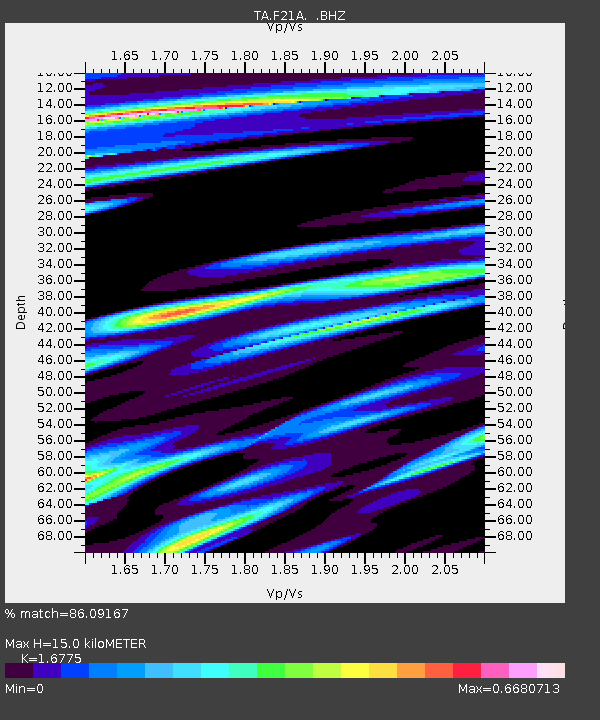
| Estimated Moho Depth: |
15.0 km |
| Estimated Crust Vp/Vs: |
1.68 |
| Assumed Crust Vp: |
6.178 km/s |
| Estimated Crust Vs: |
3.683 km/s |
| Estimated Crust Poisson's Ratio: |
0.22 |
|
| Radial Match: |
86.09167 % |
| Radial Bump: |
392 |
| Transverse Match: |
63.942436 % |
| Transverse Bump: |
400 |
| SOD ConfigId: |
2648 |
| Insert Time: |
2010-03-06 11:31:22.968 +0000 |
| GWidth: |
2.5 |
| Max Bumps: |
400 |
| Tol: |
0.001 |
|
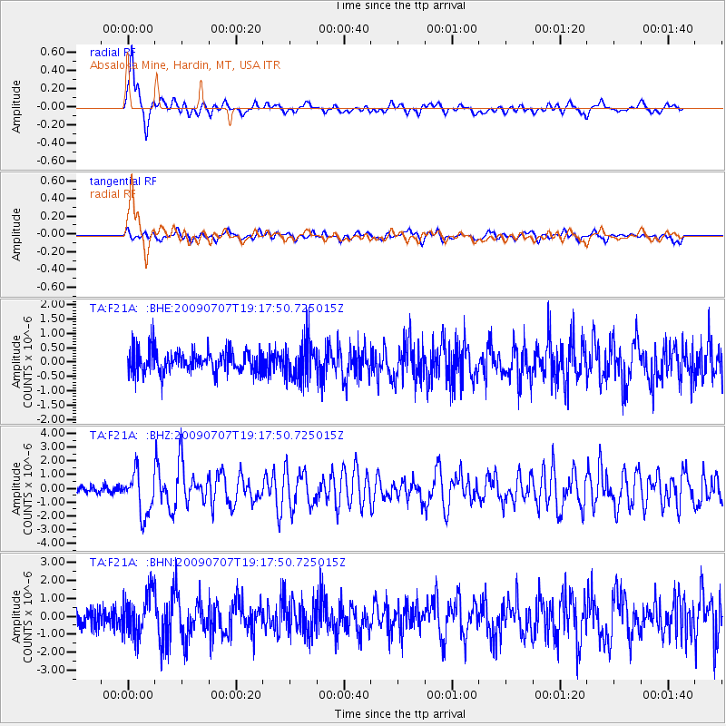
Signal To Noise
| Channel | StoN | STA | LTA |
| TA:F21A: :BHZ:20090707T19:17:50.725015Z | 7.874133 | 1.5413887E-6 | 1.9575344E-7 |
| TA:F21A: :BHN:20090707T19:17:50.725015Z | 2.5147545 | 1.1834634E-6 | 4.706079E-7 |
| TA:F21A: :BHE:20090707T19:17:50.725015Z | 1.726978 | 6.672835E-7 | 3.8638794E-7 |
| Arrivals |
| Ps | 1.8 SECOND |
| PpPs | 6.0 SECOND |
| PsPs/PpSs | 7.8 SECOND |


