You are here: Home > Network List > TA - USArray Transportable Network (new EarthScope stations) Stations List
> Station F21A Absaloka Mine, Hardin, MT, USA > Earthquake Result Viewer
F21A Absaloka Mine, Hardin, MT, USA - Earthquake Result Viewer
| Earthquake location: |
Kuril Islands |
| Earthquake latitude/longitude: |
46.0/151.5 |
| Earthquake time(UTC): |
2009/04/07 (097) 04:23:33 GMT |
| Earthquake Depth: |
31 km |
| Earthquake Magnitude: |
6.5 MB, 6.8 MS, 6.9 MW, 6.9 MW |
| Earthquake Catalog/Contributor: |
WHDF/NEIC |
|
| Network: |
TA USArray Transportable Network (new EarthScope stations) |
| Station: |
F21A Absaloka Mine, Hardin, MT, USA |
| Lat/Lon: |
45.82 N/107.12 W |
| Elevation: |
1026 m |
|
| Distance: |
65.3 deg |
| Az: |
48.981 deg |
| Baz: |
311.284 deg |
| Ray Param: |
0.058291133 |
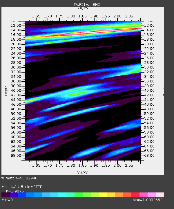
| Estimated Moho Depth: |
14.5 km |
| Estimated Crust Vp/Vs: |
1.91 |
| Assumed Crust Vp: |
6.178 km/s |
| Estimated Crust Vs: |
3.239 km/s |
| Estimated Crust Poisson's Ratio: |
0.31 |
|
| Radial Match: |
95.02946 % |
| Radial Bump: |
317 |
| Transverse Match: |
83.88618 % |
| Transverse Bump: |
400 |
| SOD ConfigId: |
2658 |
| Insert Time: |
2010-03-06 11:31:28.788 +0000 |
| GWidth: |
2.5 |
| Max Bumps: |
400 |
| Tol: |
0.001 |
|
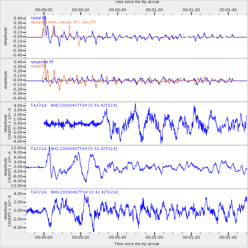
Signal To Noise
| Channel | StoN | STA | LTA |
| TA:F21A: :BHZ:20090407T04:33:41.425024Z | 29.613434 | 5.490173E-6 | 1.8539467E-7 |
| TA:F21A: :BHN:20090407T04:33:41.425024Z | 4.121258 | 1.7613654E-6 | 4.273854E-7 |
| TA:F21A: :BHE:20090407T04:33:41.425024Z | 3.5829647 | 1.4067037E-6 | 3.9260888E-7 |
| Arrivals |
| Ps | 2.2 SECOND |
| PpPs | 6.6 SECOND |
| PsPs/PpSs | 8.8 SECOND |


