You are here: Home > Network List > TA - USArray Transportable Network (new EarthScope stations) Stations List
> Station F21A Absaloka Mine, Hardin, MT, USA > Earthquake Result Viewer
F21A Absaloka Mine, Hardin, MT, USA - Earthquake Result Viewer
| Earthquake location: |
Off Coast Of Ecuador |
| Earthquake latitude/longitude: |
1.4/-85.2 |
| Earthquake time(UTC): |
2009/05/10 (130) 01:16:06 GMT |
| Earthquake Depth: |
6.0 km |
| Earthquake Magnitude: |
5.5 MB, 5.7 MS, 6.1 MW, 6.1 MW |
| Earthquake Catalog/Contributor: |
WHDF/NEIC |
|
| Network: |
TA USArray Transportable Network (new EarthScope stations) |
| Station: |
F21A Absaloka Mine, Hardin, MT, USA |
| Lat/Lon: |
45.82 N/107.12 W |
| Elevation: |
1026 m |
|
| Distance: |
48.3 deg |
| Az: |
339.493 deg |
| Baz: |
149.945 deg |
| Ray Param: |
0.06947906 |
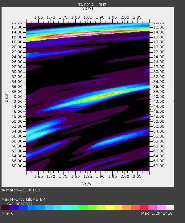
| Estimated Moho Depth: |
14.5 km |
| Estimated Crust Vp/Vs: |
1.81 |
| Assumed Crust Vp: |
6.178 km/s |
| Estimated Crust Vs: |
3.423 km/s |
| Estimated Crust Poisson's Ratio: |
0.28 |
|
| Radial Match: |
81.89183 % |
| Radial Bump: |
342 |
| Transverse Match: |
73.69668 % |
| Transverse Bump: |
400 |
| SOD ConfigId: |
2760 |
| Insert Time: |
2010-03-06 11:31:31.357 +0000 |
| GWidth: |
2.5 |
| Max Bumps: |
400 |
| Tol: |
0.001 |
|
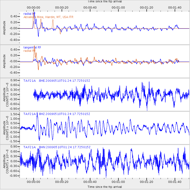
Signal To Noise
| Channel | StoN | STA | LTA |
| TA:F21A: :BHZ:20090510T01:24:17.725015Z | 7.6299295 | 7.6282896E-7 | 9.997851E-8 |
| TA:F21A: :BHN:20090510T01:24:17.725015Z | 2.4292018 | 3.8795727E-7 | 1.5970566E-7 |
| TA:F21A: :BHE:20090510T01:24:17.725015Z | 1.8741611 | 2.5987666E-7 | 1.3866293E-7 |
| Arrivals |
| Ps | 2.0 SECOND |
| PpPs | 6.2 SECOND |
| PsPs/PpSs | 8.2 SECOND |


