You are here: Home > Network List > CI - Caltech Regional Seismic Network Stations List
> Station MPP McPhearson Peak > Earthquake Result Viewer
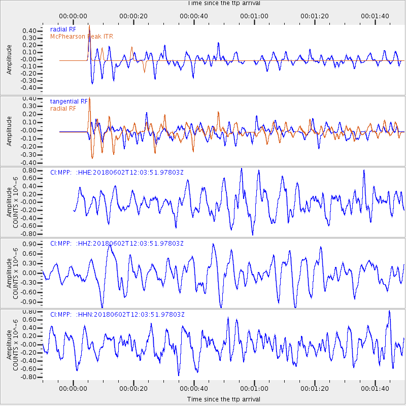
MPP McPhearson Peak - Earthquake Result Viewer
*The percent match for this event was below the threshold and hence no stack was calculated.
| Earthquake location: |
Samoa Islands Region |
| Earthquake latitude/longitude: |
-14.8/-173.1 |
| Earthquake time(UTC): |
2018/06/02 (153) 11:53:06 GMT |
| Earthquake Depth: |
50 km |
| Earthquake Magnitude: |
5.6 mb |
| Earthquake Catalog/Contributor: |
NEIC PDE/us |
|
| Network: |
CI Caltech Regional Seismic Network |
| Station: |
MPP McPhearson Peak |
| Lat/Lon: |
34.89 N/119.81 W |
| Elevation: |
1739 m |
|
| Distance: |
70.7 deg |
| Az: |
44.3 deg |
| Baz: |
235.269 deg |
| Ray Param: |
$rayparam |
*The percent match for this event was below the threshold and hence was not used in the summary stack. |
|
| Radial Match: |
68.57594 % |
| Radial Bump: |
400 |
| Transverse Match: |
54.499626 % |
| Transverse Bump: |
400 |
| SOD ConfigId: |
13570011 |
| Insert Time: |
2019-04-30 08:14:21.799 +0000 |
| GWidth: |
2.5 |
| Max Bumps: |
400 |
| Tol: |
0.001 |
|
Signal To Noise
| Channel | StoN | STA | LTA |
| CI:MPP: :HHZ:20180602T12:03:51.97803Z | 0.7735833 | 1.5175738E-7 | 1.9617457E-7 |
| CI:MPP: :HHN:20180602T12:03:51.97803Z | 1.3152198 | 3.6142384E-7 | 2.748011E-7 |
| CI:MPP: :HHE:20180602T12:03:51.97803Z | 0.56924975 | 1.2239325E-7 | 2.1500799E-7 |
| Arrivals |
| Ps | |
| PpPs | |
| PsPs/PpSs | |


