You are here: Home > Network List > TA - USArray Transportable Network (new EarthScope stations) Stations List
> Station 121A Cookes Peak, Deming, NM, USA > Earthquake Result Viewer
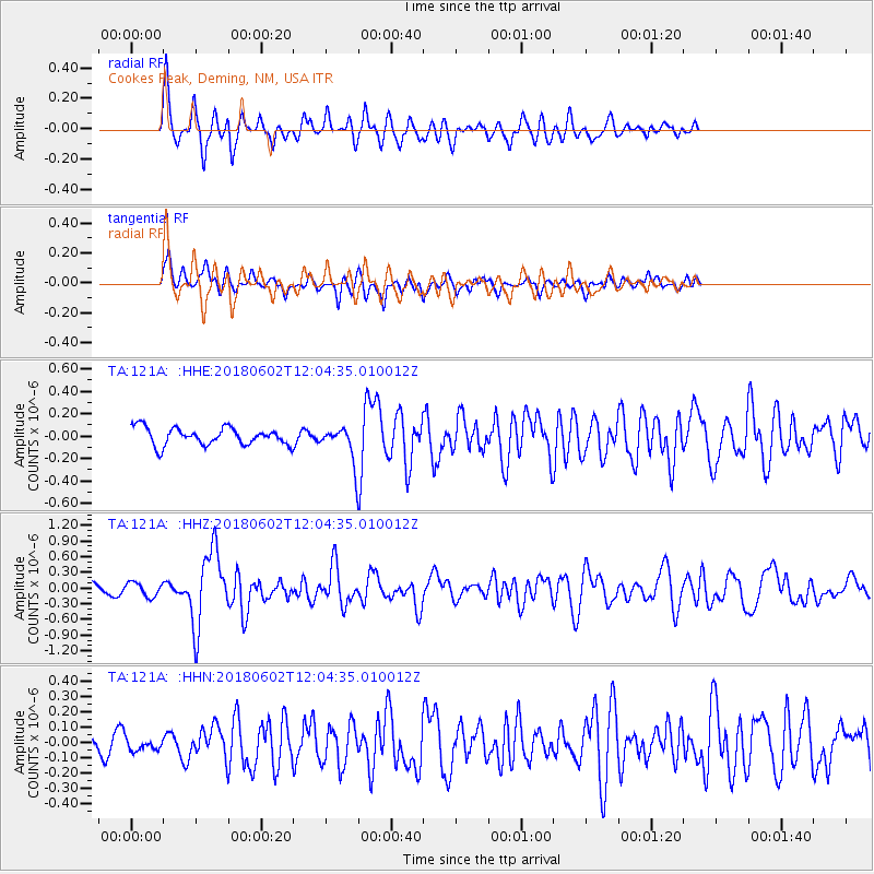
121A Cookes Peak, Deming, NM, USA - Earthquake Result Viewer
*The percent match for this event was below the threshold and hence no stack was calculated.
| Earthquake location: |
Samoa Islands Region |
| Earthquake latitude/longitude: |
-14.8/-173.1 |
| Earthquake time(UTC): |
2018/06/02 (153) 11:53:06 GMT |
| Earthquake Depth: |
50 km |
| Earthquake Magnitude: |
5.6 mb |
| Earthquake Catalog/Contributor: |
NEIC PDE/us |
|
| Network: |
TA USArray Transportable Network (new EarthScope stations) |
| Station: |
121A Cookes Peak, Deming, NM, USA |
| Lat/Lon: |
32.53 N/107.79 W |
| Elevation: |
1652 m |
|
| Distance: |
78.1 deg |
| Az: |
51.657 deg |
| Baz: |
243.916 deg |
| Ray Param: |
$rayparam |
*The percent match for this event was below the threshold and hence was not used in the summary stack. |
|
| Radial Match: |
81.87258 % |
| Radial Bump: |
400 |
| Transverse Match: |
74.46298 % |
| Transverse Bump: |
400 |
| SOD ConfigId: |
13570011 |
| Insert Time: |
2019-04-30 08:18:23.510 +0000 |
| GWidth: |
2.5 |
| Max Bumps: |
400 |
| Tol: |
0.001 |
|
Signal To Noise
| Channel | StoN | STA | LTA |
| TA:121A: :HHZ:20180602T12:04:35.010012Z | 1.3509374 | 1.3416465E-7 | 9.931226E-8 |
| TA:121A: :HHN:20180602T12:04:35.010012Z | 0.32590368 | 3.714219E-8 | 1.1396677E-7 |
| TA:121A: :HHE:20180602T12:04:35.010012Z | 0.85716325 | 7.006098E-8 | 8.173586E-8 |
| Arrivals |
| Ps | |
| PpPs | |
| PsPs/PpSs | |


