You are here: Home > Network List > TA - USArray Transportable Network (new EarthScope stations) Stations List
> Station B18K Kokolik River, AK, USA > Earthquake Result Viewer
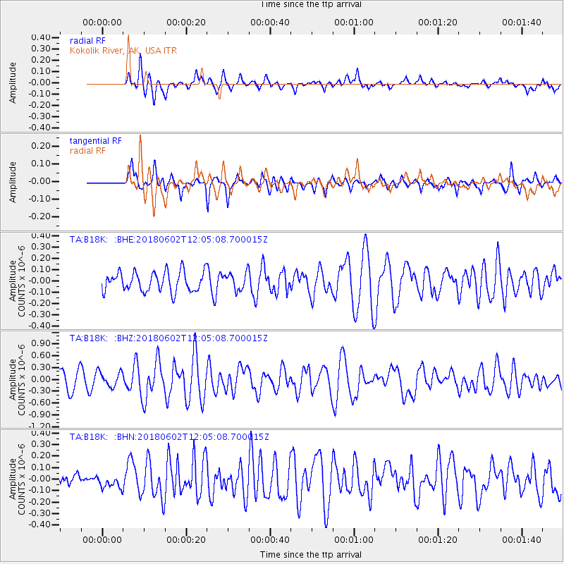
B18K Kokolik River, AK, USA - Earthquake Result Viewer
*The percent match for this event was below the threshold and hence no stack was calculated.
| Earthquake location: |
Samoa Islands Region |
| Earthquake latitude/longitude: |
-14.8/-173.1 |
| Earthquake time(UTC): |
2018/06/02 (153) 11:53:06 GMT |
| Earthquake Depth: |
50 km |
| Earthquake Magnitude: |
5.6 mb |
| Earthquake Catalog/Contributor: |
NEIC PDE/us |
|
| Network: |
TA USArray Transportable Network (new EarthScope stations) |
| Station: |
B18K Kokolik River, AK, USA |
| Lat/Lon: |
69.36 N/161.80 W |
| Elevation: |
222 m |
|
| Distance: |
84.3 deg |
| Az: |
4.005 deg |
| Baz: |
190.987 deg |
| Ray Param: |
$rayparam |
*The percent match for this event was below the threshold and hence was not used in the summary stack. |
|
| Radial Match: |
69.89341 % |
| Radial Bump: |
400 |
| Transverse Match: |
68.40663 % |
| Transverse Bump: |
344 |
| SOD ConfigId: |
13570011 |
| Insert Time: |
2019-04-30 08:18:30.802 +0000 |
| GWidth: |
2.5 |
| Max Bumps: |
400 |
| Tol: |
0.001 |
|
Signal To Noise
| Channel | StoN | STA | LTA |
| TA:B18K: :BHZ:20180602T12:05:08.700015Z | 0.7890525 | 1.8686261E-7 | 2.3681899E-7 |
| TA:B18K: :BHN:20180602T12:05:08.700015Z | 1.1913524 | 5.982777E-8 | 5.0218368E-8 |
| TA:B18K: :BHE:20180602T12:05:08.700015Z | 1.3910768 | 1.137196E-7 | 8.174933E-8 |
| Arrivals |
| Ps | |
| PpPs | |
| PsPs/PpSs | |


