You are here: Home > Network List > TA - USArray Transportable Network (new EarthScope stations) Stations List
> Station C16K Lisburne Hills, AK, USA > Earthquake Result Viewer
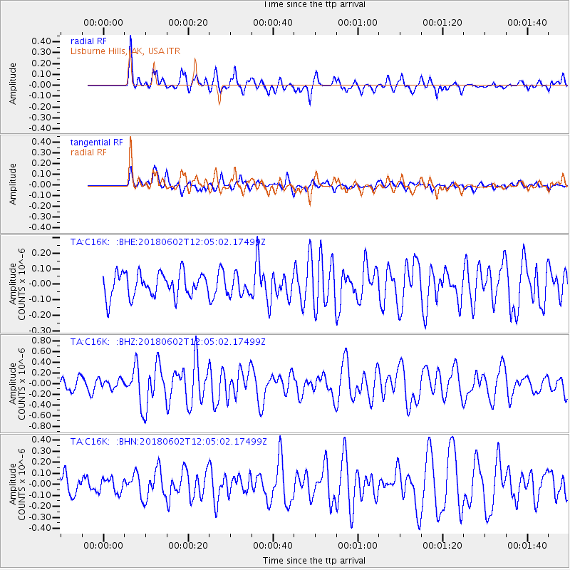
C16K Lisburne Hills, AK, USA - Earthquake Result Viewer
*The percent match for this event was below the threshold and hence no stack was calculated.
| Earthquake location: |
Samoa Islands Region |
| Earthquake latitude/longitude: |
-14.8/-173.1 |
| Earthquake time(UTC): |
2018/06/02 (153) 11:53:06 GMT |
| Earthquake Depth: |
50 km |
| Earthquake Magnitude: |
5.6 mb |
| Earthquake Catalog/Contributor: |
NEIC PDE/us |
|
| Network: |
TA USArray Transportable Network (new EarthScope stations) |
| Station: |
C16K Lisburne Hills, AK, USA |
| Lat/Lon: |
68.27 N/165.34 W |
| Elevation: |
102 m |
|
| Distance: |
83.0 deg |
| Az: |
2.905 deg |
| Baz: |
187.565 deg |
| Ray Param: |
$rayparam |
*The percent match for this event was below the threshold and hence was not used in the summary stack. |
|
| Radial Match: |
73.570366 % |
| Radial Bump: |
379 |
| Transverse Match: |
67.20646 % |
| Transverse Bump: |
400 |
| SOD ConfigId: |
13570011 |
| Insert Time: |
2019-04-30 08:18:32.700 +0000 |
| GWidth: |
2.5 |
| Max Bumps: |
400 |
| Tol: |
0.001 |
|
Signal To Noise
| Channel | StoN | STA | LTA |
| TA:C16K: :BHZ:20180602T12:05:02.17499Z | 0.8667298 | 8.156744E-8 | 9.4109424E-8 |
| TA:C16K: :BHN:20180602T12:05:02.17499Z | 0.78627706 | 6.5064214E-8 | 8.274972E-8 |
| TA:C16K: :BHE:20180602T12:05:02.17499Z | 1.0641047 | 8.489021E-8 | 7.977618E-8 |
| Arrivals |
| Ps | |
| PpPs | |
| PsPs/PpSs | |


