You are here: Home > Network List > TA - USArray Transportable Network (new EarthScope stations) Stations List
> Station D25K Kavik River, AK, USA > Earthquake Result Viewer
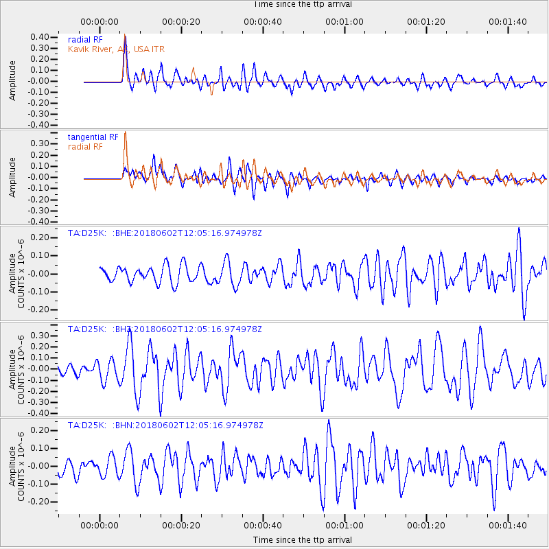
D25K Kavik River, AK, USA - Earthquake Result Viewer
*The percent match for this event was below the threshold and hence no stack was calculated.
| Earthquake location: |
Samoa Islands Region |
| Earthquake latitude/longitude: |
-14.8/-173.1 |
| Earthquake time(UTC): |
2018/06/02 (153) 11:53:06 GMT |
| Earthquake Depth: |
50 km |
| Earthquake Magnitude: |
5.6 mb |
| Earthquake Catalog/Contributor: |
NEIC PDE/us |
|
| Network: |
TA USArray Transportable Network (new EarthScope stations) |
| Station: |
D25K Kavik River, AK, USA |
| Lat/Lon: |
69.32 N/146.38 W |
| Elevation: |
770 m |
|
| Distance: |
86.0 deg |
| Az: |
9.217 deg |
| Baz: |
205.862 deg |
| Ray Param: |
$rayparam |
*The percent match for this event was below the threshold and hence was not used in the summary stack. |
|
| Radial Match: |
68.97185 % |
| Radial Bump: |
400 |
| Transverse Match: |
72.55496 % |
| Transverse Bump: |
400 |
| SOD ConfigId: |
13570011 |
| Insert Time: |
2019-04-30 08:18:44.351 +0000 |
| GWidth: |
2.5 |
| Max Bumps: |
400 |
| Tol: |
0.001 |
|
Signal To Noise
| Channel | StoN | STA | LTA |
| TA:D25K: :BHZ:20180602T12:05:16.974978Z | 2.577149 | 9.51258E-8 | 3.6911256E-8 |
| TA:D25K: :BHN:20180602T12:05:16.974978Z | 0.9065566 | 5.3703587E-8 | 5.923909E-8 |
| TA:D25K: :BHE:20180602T12:05:16.974978Z | 0.9843709 | 4.0356582E-8 | 4.099733E-8 |
| Arrivals |
| Ps | |
| PpPs | |
| PsPs/PpSs | |


