You are here: Home > Network List > TA - USArray Transportable Network (new EarthScope stations) Stations List
> Station E20K Nigu River, AK, USA > Earthquake Result Viewer
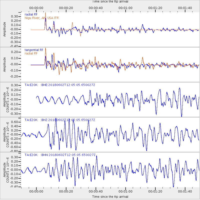
E20K Nigu River, AK, USA - Earthquake Result Viewer
*The percent match for this event was below the threshold and hence no stack was calculated.
| Earthquake location: |
Samoa Islands Region |
| Earthquake latitude/longitude: |
-14.8/-173.1 |
| Earthquake time(UTC): |
2018/06/02 (153) 11:53:06 GMT |
| Earthquake Depth: |
50 km |
| Earthquake Magnitude: |
5.6 mb |
| Earthquake Catalog/Contributor: |
NEIC PDE/us |
|
| Network: |
TA USArray Transportable Network (new EarthScope stations) |
| Station: |
E20K Nigu River, AK, USA |
| Lat/Lon: |
68.26 N/156.19 W |
| Elevation: |
866 m |
|
| Distance: |
83.7 deg |
| Az: |
6.263 deg |
| Baz: |
196.453 deg |
| Ray Param: |
$rayparam |
*The percent match for this event was below the threshold and hence was not used in the summary stack. |
|
| Radial Match: |
82.19921 % |
| Radial Bump: |
400 |
| Transverse Match: |
72.82606 % |
| Transverse Bump: |
400 |
| SOD ConfigId: |
13570011 |
| Insert Time: |
2019-04-30 08:18:48.331 +0000 |
| GWidth: |
2.5 |
| Max Bumps: |
400 |
| Tol: |
0.001 |
|
Signal To Noise
| Channel | StoN | STA | LTA |
| TA:E20K: :BHZ:20180602T12:05:05.650027Z | 1.065837 | 8.764942E-8 | 8.223529E-8 |
| TA:E20K: :BHN:20180602T12:05:05.650027Z | 0.9479661 | 3.99214E-8 | 4.2112685E-8 |
| TA:E20K: :BHE:20180602T12:05:05.650027Z | 0.97084224 | 4.7695398E-8 | 4.9127856E-8 |
| Arrivals |
| Ps | |
| PpPs | |
| PsPs/PpSs | |


