You are here: Home > Network List > TA - USArray Transportable Network (new EarthScope stations) Stations List
> Station I17K Unalakleet, AK, USA > Earthquake Result Viewer
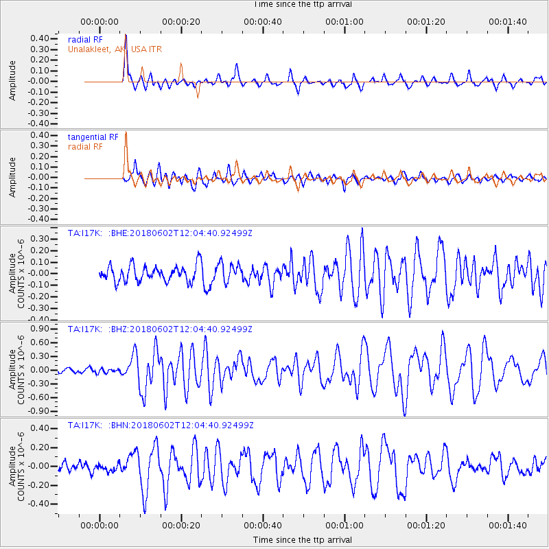
I17K Unalakleet, AK, USA - Earthquake Result Viewer
*The percent match for this event was below the threshold and hence no stack was calculated.
| Earthquake location: |
Samoa Islands Region |
| Earthquake latitude/longitude: |
-14.8/-173.1 |
| Earthquake time(UTC): |
2018/06/02 (153) 11:53:06 GMT |
| Earthquake Depth: |
50 km |
| Earthquake Magnitude: |
5.6 mb |
| Earthquake Catalog/Contributor: |
NEIC PDE/us |
|
| Network: |
TA USArray Transportable Network (new EarthScope stations) |
| Station: |
I17K Unalakleet, AK, USA |
| Lat/Lon: |
63.89 N/160.70 W |
| Elevation: |
105 m |
|
| Distance: |
79.0 deg |
| Az: |
5.561 deg |
| Baz: |
192.229 deg |
| Ray Param: |
$rayparam |
*The percent match for this event was below the threshold and hence was not used in the summary stack. |
|
| Radial Match: |
74.91674 % |
| Radial Bump: |
400 |
| Transverse Match: |
65.79839 % |
| Transverse Bump: |
400 |
| SOD ConfigId: |
13570011 |
| Insert Time: |
2019-04-30 08:19:28.949 +0000 |
| GWidth: |
2.5 |
| Max Bumps: |
400 |
| Tol: |
0.001 |
|
Signal To Noise
| Channel | StoN | STA | LTA |
| TA:I17K: :BHZ:20180602T12:04:40.92499Z | 0.66803676 | 4.5715026E-8 | 6.84319E-8 |
| TA:I17K: :BHN:20180602T12:04:40.92499Z | 0.75047874 | 3.5140165E-8 | 4.682366E-8 |
| TA:I17K: :BHE:20180602T12:04:40.92499Z | 1.9702859 | 1.1694007E-7 | 5.9351827E-8 |
| Arrivals |
| Ps | |
| PpPs | |
| PsPs/PpSs | |


