You are here: Home > Network List > TA - USArray Transportable Network (new EarthScope stations) Stations List
> Station I30M Mount Dempster, Yukon, CAN > Earthquake Result Viewer
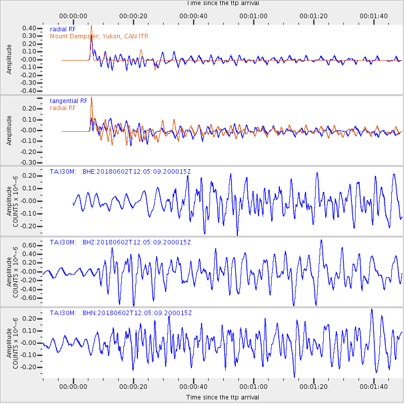
I30M Mount Dempster, Yukon, CAN - Earthquake Result Viewer
*The percent match for this event was below the threshold and hence no stack was calculated.
| Earthquake location: |
Samoa Islands Region |
| Earthquake latitude/longitude: |
-14.8/-173.1 |
| Earthquake time(UTC): |
2018/06/02 (153) 11:53:06 GMT |
| Earthquake Depth: |
50 km |
| Earthquake Magnitude: |
5.6 mb |
| Earthquake Catalog/Contributor: |
NEIC PDE/us |
|
| Network: |
TA USArray Transportable Network (new EarthScope stations) |
| Station: |
I30M Mount Dempster, Yukon, CAN |
| Lat/Lon: |
65.22 N/136.38 W |
| Elevation: |
1399 m |
|
| Distance: |
84.4 deg |
| Az: |
14.668 deg |
| Baz: |
215.539 deg |
| Ray Param: |
$rayparam |
*The percent match for this event was below the threshold and hence was not used in the summary stack. |
|
| Radial Match: |
79.405655 % |
| Radial Bump: |
400 |
| Transverse Match: |
80.831535 % |
| Transverse Bump: |
400 |
| SOD ConfigId: |
13570011 |
| Insert Time: |
2019-04-30 08:19:34.868 +0000 |
| GWidth: |
2.5 |
| Max Bumps: |
400 |
| Tol: |
0.001 |
|
Signal To Noise
| Channel | StoN | STA | LTA |
| TA:I30M: :BHZ:20180602T12:05:09.200015Z | 1.1549023 | 5.127047E-8 | 4.439377E-8 |
| TA:I30M: :BHN:20180602T12:05:09.200015Z | 0.6332575 | 2.508095E-8 | 3.9606245E-8 |
| TA:I30M: :BHE:20180602T12:05:09.200015Z | 1.9872413 | 7.695394E-8 | 3.8724007E-8 |
| Arrivals |
| Ps | |
| PpPs | |
| PsPs/PpSs | |


