You are here: Home > Network List > TA - USArray Transportable Network (new EarthScope stations) Stations List
> Station M11K Mekoryuk, AK, USA > Earthquake Result Viewer
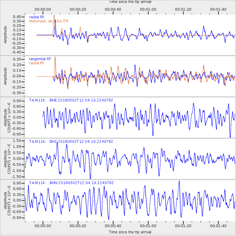
M11K Mekoryuk, AK, USA - Earthquake Result Viewer
*The percent match for this event was below the threshold and hence no stack was calculated.
| Earthquake location: |
Samoa Islands Region |
| Earthquake latitude/longitude: |
-14.8/-173.1 |
| Earthquake time(UTC): |
2018/06/02 (153) 11:53:06 GMT |
| Earthquake Depth: |
50 km |
| Earthquake Magnitude: |
5.6 mb |
| Earthquake Catalog/Contributor: |
NEIC PDE/us |
|
| Network: |
TA USArray Transportable Network (new EarthScope stations) |
| Station: |
M11K Mekoryuk, AK, USA |
| Lat/Lon: |
60.38 N/166.20 W |
| Elevation: |
3.0 m |
|
| Distance: |
75.1 deg |
| Az: |
3.543 deg |
| Baz: |
186.913 deg |
| Ray Param: |
$rayparam |
*The percent match for this event was below the threshold and hence was not used in the summary stack. |
|
| Radial Match: |
65.61748 % |
| Radial Bump: |
400 |
| Transverse Match: |
64.56028 % |
| Transverse Bump: |
400 |
| SOD ConfigId: |
13570011 |
| Insert Time: |
2019-04-30 08:19:50.366 +0000 |
| GWidth: |
2.5 |
| Max Bumps: |
400 |
| Tol: |
0.001 |
|
Signal To Noise
| Channel | StoN | STA | LTA |
| TA:M11K: :BHZ:20180602T12:04:19.224978Z | 1.069704 | 2.674421E-7 | 2.50015E-7 |
| TA:M11K: :BHN:20180602T12:04:19.224978Z | 1.2130237 | 3.2495217E-7 | 2.6788607E-7 |
| TA:M11K: :BHE:20180602T12:04:19.224978Z | 1.3137294 | 3.7939213E-7 | 2.8879018E-7 |
| Arrivals |
| Ps | |
| PpPs | |
| PsPs/PpSs | |


