You are here: Home > Network List > TA - USArray Transportable Network (new EarthScope stations) Stations List
> Station TUL3 Leonard, OK, USA > Earthquake Result Viewer
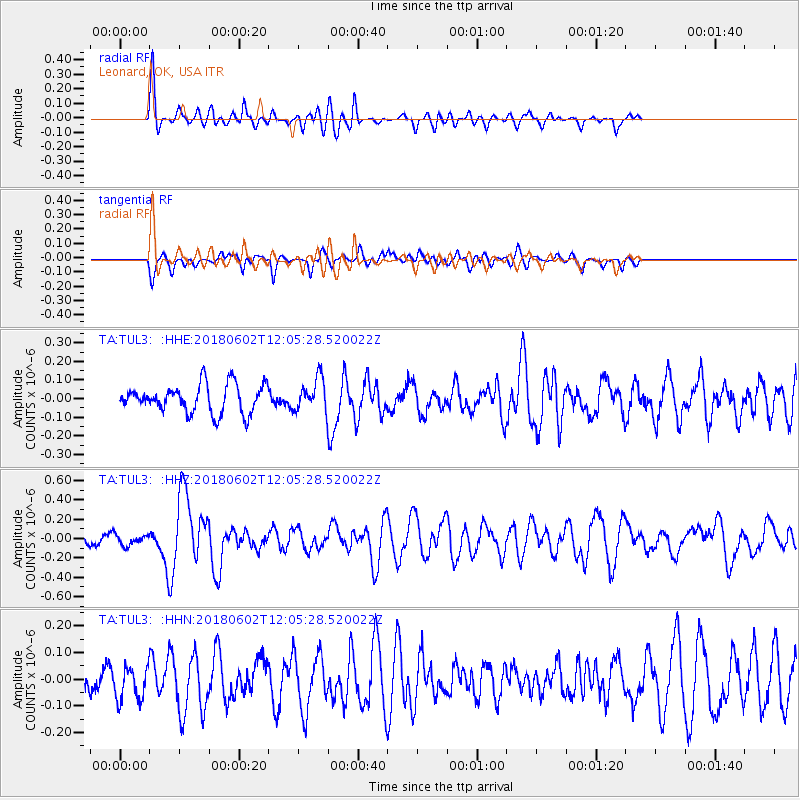
TUL3 Leonard, OK, USA - Earthquake Result Viewer
*The percent match for this event was below the threshold and hence no stack was calculated.
| Earthquake location: |
Samoa Islands Region |
| Earthquake latitude/longitude: |
-14.8/-173.1 |
| Earthquake time(UTC): |
2018/06/02 (153) 11:53:06 GMT |
| Earthquake Depth: |
50 km |
| Earthquake Magnitude: |
5.6 mb |
| Earthquake Catalog/Contributor: |
NEIC PDE/us |
|
| Network: |
TA USArray Transportable Network (new EarthScope stations) |
| Station: |
TUL3 Leonard, OK, USA |
| Lat/Lon: |
35.91 N/95.79 W |
| Elevation: |
265 m |
|
| Distance: |
88.6 deg |
| Az: |
52.394 deg |
| Baz: |
250.735 deg |
| Ray Param: |
$rayparam |
*The percent match for this event was below the threshold and hence was not used in the summary stack. |
|
| Radial Match: |
73.03138 % |
| Radial Bump: |
400 |
| Transverse Match: |
48.16014 % |
| Transverse Bump: |
400 |
| SOD ConfigId: |
13570011 |
| Insert Time: |
2019-04-30 08:20:27.729 +0000 |
| GWidth: |
2.5 |
| Max Bumps: |
400 |
| Tol: |
0.001 |
|
Signal To Noise
| Channel | StoN | STA | LTA |
| TA:TUL3: :HHZ:20180602T12:05:28.520022Z | 0.69043905 | 5.4451466E-8 | 7.8864986E-8 |
| TA:TUL3: :HHN:20180602T12:05:28.520022Z | 1.1013042 | 6.368211E-8 | 5.782427E-8 |
| TA:TUL3: :HHE:20180602T12:05:28.520022Z | 0.738627 | 5.3551084E-8 | 7.2500846E-8 |
| Arrivals |
| Ps | |
| PpPs | |
| PsPs/PpSs | |


